Structure · Built 1898
Billerica Town Water Supply Pumping Station
Billerica Town Water Supply Pumping Station
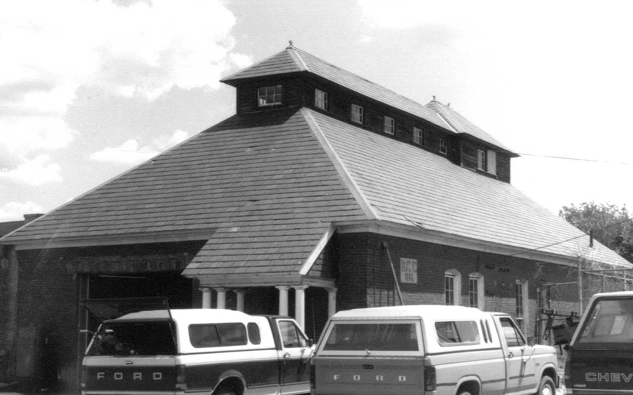
| Address | 250 Boston Rd |
| MACRIS ID | BIL.132 |
| Built | 1898 |
The Billerica Town Water Supply Pumping Station is the brick building the town put up in 1898 in "Hutchins Meadow," on the east side of Boston Road (then the Lowell road, or the Mock Meadow causeway) a short way north of the Concord River bridge at North Billerica. Designed by the Boston architect Ernest N. Boyden, it measures about 78 by 37 feet, with red brick walls, segmental arches over the windows, a hipped slate roof with a clapboarded clerestory, and an entrance framed by columns. It held two pumping engines and two boilers that lifted water from driven wells in the meadow into the town's first public water system.
The meadow has a long recorded history. In 1795 Edward Rand, a Newburyport merchant, sold Enoch Chase, a Billerica cordwainer, a seventy-acre farm near the North Burying Ground together with "upland and Meadow called mock meadow containing about fifteen acres" on the west side of the Concord River. A year later Chase sold the same land to Thomas Richardson for $1,766.66. When Richardson died in 1828 his heirs divided the estate by deeds of March 7, 1829, and the meadow lot of fourteen acres "on Mock meadow causway" went to John French, a Boston merchant married to one of the daughters.
In 1835 French sold the Chase place and the meadow lot to another son-in-law, Josiah Stevens, for $3,500, and Stevens mortgaged them back to French together with the adjoining fourteen acres that ran south along the river "to the Bridge." Stevens died early in 1840. His inventory lists "Wood & Pasture land by Mock Meadow," and his administrator, Marshall Preston, sold the equity of redemption in "another lot of land containing thirty acres more or less ... at Concord river at the westerly end of the corner Bridge" at auction on May 18, 1840 to George Gage of Waterford, New York.
Gage sold the thirty acres to William Blanchard, a Billerica farmer, in December 1845 for $800. Blanchard sold them in 1863 to Daniel Floyd, a carpenter, for $1,150; Floyd sold them in 1875 to Benjamin J. Gilbert for $1,400; and in 1880 Gilbert sold them, with the fourteen-acre "Newman place" across the road, to Jason K. Hutchins. After Jason's death his administrator, Dudley Foster, sold both tracts at auction on December 22, 1888 to William H. Hutchins for $4,050, and the meadow took the Hutchins name.
At a special town meeting on September 16, 1897 Billerica accepted Chapter 471 of the Acts of 1897, "An Act to Supply the Town of Billerica with Water," and chose a Board of Water Commissioners, Frederick S. Clark, J. Nelson Parker and Charles H. Kohlrausch Jr. The engineer, Percy M. Blake of Hyde Park, tested wells along the Concord River and Content Brook and chose the Hutchins meadow. On May 11, 1898, "with the recommendation and advice of the State Board of Health," the commissioners took for the town a parcel "on the highway known as the Causeway Road, being the principal highway between Lowell and Billerica," running 743 feet along the road from a bound 357 feet south of Hutchins's northerly line to a bound "near a pond hole," and about 599 feet east to the Concord River. Hutchins settled for $2,150 on November 10, 1899, releasing all claims for damages and binding the town to "fence on all sides when necessary." Every later deed of the Hutchins land on both sides of the road, from Albert H. Jones (1900) and the Sanfords (1905) to the Wagners (1945), excepts the water works taking.
The station was built during 1898 while pipe was laid through the Center and North Billerica, a standpipe went up on Crosby Hill and 94 hydrants were set. The 1901 town report puts the cost of the pumping station at $6,825.42 and the pumping plant at $9,629.02, and notes that pumping then took "less than three hours per day." That year the town considered adding an electric light plant to the station, to be run by the same engineer and boilers. In 1933 town meeting voted to reconstruct the pumping station and build a new garage for the Department of Public Works, using relief labor, and sold the obsolete machinery; the town report for that year says the highway and water department equipment "are now housed in the new public works building, formerly the pumping station." The coal-fired plant was converted to oil about the same time.
The town still owns the lot. In 1993 the old station served as a garage for water department vehicles behind the water department office, part of a public works yard of about thirteen acres; the assessor now lists the parcel (Map 22, Parcel 18) as 14 acres held by the Department of Public Works, with buildings of 1971. In 2005 the town granted Massachusetts Electric Company an easement for a pole and underground lines to serve a "raw water pump station" on the site.
References
- MACRIS BIL.132
- Billerica assessor, 250 Boston Rd, parcel 22-18-0: Town of Billerica, Public Works, 14 acres
Title References
| Date | Type | Grantor | Grantee | Summary | Recorded |
|---|---|---|---|---|---|
| December 14, 1796 | Deed | Edward Rand of Newburyport, merchant (wife Martha releasing dower) | Enoch Chase of Billerica, cordwainer | Edward Rand to Enoch Chase, 1795: includes the fifteen-acre Mock Meadow on the Concord River | 123/269 (South) |
Billerica town book 9, pages 269-270. For 500 pounds, three pieces of land in Billerica, the first "containing about seventy acres," beginning at a heap of stones at "the high way leading from Billerica meeting house to the Ford way," running southerly by the highway about 108 rods, easterly "by the burying place" about 20 rods, southerly about 22 rods by the burying place and land of William Patten "to the road leading from said highway to Tewksbury," easterly by that road about 66 rods to Edward Farmer's land, then by Farmer, the Bowers and Patten back to the start, "with the buildings and appurtenances"; also 15 acres of "mock meadow" west of Concord River and about six acres "being the same I purchased of William Frost." Dated Apr. 10, 1795, acknowledged Apr. 20, 1796, recorded Dec. 14, 1796. No title recital for the seventy acres.
Title passed to:
|
|||||
| December 14, 1796 | Deed | Enoch Chase of Billerica, cordwainer (wife Sarah releasing dower) | Thomas Richardson of Billerica, gentleman | Enoch Chase to Thomas Richardson, 1796: the Mock Meadow piece | 123/271 (South) |
Billerica town book 9, pages 271-273. For $1,766.66, the same three pieces, the first "about seventy acres" on the east side of the highway from the meeting house to the Fordway, running south about 108 rods "to the burying place," east and south by the burying place and William Patten to the road to Tewksbury, "with the buildings and appurtenances." Dated Apr. 1, 1796, acknowledged Dec. 13 and recorded Dec. 14, 1796. The corner acre that Richardson sold to Francis Blanchard in 1800, between the burying ground and the Salem road, came out of this tract; across the road stood Richardson's own tavern, bought of Reuben Duren in 1795.
Title from:
Title passed to:
|
|||||
| 1828 | Administration | Estate of Thomas Richardson of Billerica, gentleman, died intestate 1828 | Joseph Locke of Billerica, administrator; the heirs | Thomas Richardson dies 1828; his heirs divide the land | Probate #19177 |
Thomas Richardson "has died within sixty days last past," his administrator wrote in October 1828. His son T. Richardson Jr. declined on Sept. 20, 1828 and joined the heirs in asking that Joseph Locke of Billerica be appointed, which the court at Chelmsford did on Oct. 7, 1828, on a $5,000 bond with Josiah Stevens of Billerica (Richardson's son-in-law, who had kept the tavern) and John French of Boston, merchant; Artemas and Lydia Rogers witnessed the bond. The file holds only the appointment papers and the notice to creditors; no inventory or division survives in it, and the heirs settled the real estate among themselves by deed (the tavern going to his daughters Lydia Rogers and Elizabeth Richardson). Middlesex probate case 19177.
Title from:
Title passed to:
|
|||||
| April 17, 1830 | Quitclaim | Josiah Stevens of Billerica, gentleman, and Abigail his wife in her right, with the other heirs of Thomas Richardson (John and Ann Thompson, Artemas and Lydia Rogers, Sarah Kendall, Elizabeth Richardson, George W. H., Hannah H. F. and Judith E. Rogers) | John French of Boston, merchant (husband of Mary, an heir) | Richardson heirs divide the estate; Mock Meadow lot to John French, 1829 | 296/235 (South) |
Billerica town book 14, pages 277-279. Dated March 7, 1829, acknowledged before Joseph Locke; division deed among the heirs of Thomas Richardson. "In consideration of twenty nine hundred and forty seven dollars and twenty six cents" the heirs quitclaim to French the Chase place (73 acres 63 poles, and about nine acres south of the Salem road by the North Burying Ground), "a lot of wood and pasture land containing fourteen acres three rods and two perches situate on Mock meadow causway," from the southwest corner by land of Josiah Stevens, by a ditch to Concord River, by the river to land of Lucy H. Foster, to a marked oak, by a ditch eighteen rods, to the causeway and by it eleven rods, and a wood lot in Chelmsford. The same day the heirs released another part of the estate to Josiah Stevens (book 14, page 276).
Title from:
Title passed to:
|
|||||
| February 11, 1835 | Warranty Deed | John French of Boston, merchant, and Mary French, his wife, in her own right | Josiah Stevens of Billerica | French to Josiah Stevens, the Mock Meadow lot, 1835 | 338/159 (South) |
Billerica town book 15, pages 38-39. Dated February 7, 1835, acknowledged in Boston before Willard Phillips. "In consideration of thirty five hundred dollars" French and his wife convey the Chase place of 64 acres and "a lot of wood and pasture land containing fourteen acres more or less situated on Mark Meadow cause way (so called)," from the southwest corner at land of Josiah Stevens, by a ditch to Concord River, down the river to Lucy Foster, to a marked oak, by a ditch eighteen rods, to the causeway and by it eleven rods, "being the same premises conveyed to said French by the heirs of the late Thomas Richardson of Billerica by deed dated March 7th A.D. 1829 ... Book 296, Page 235."
Title from:
|
|||||
| February 11, 1835 | Mortgage | Josiah Stevens of Billerica, yeoman (Abigail Stevens releasing dower) | John French of Boston, merchant | Stevens mortgages both river lots to French, 1835 | 338/161 (South) |
Billerica town book 15, pages 40-41. Dated February 7, 1835. For $3,200 Stevens mortgages back the Chase place, the fourteen-acre wood and pasture lot "on Mark meadow causeway," "being the same premises that said French and his wife Mary conveyed to me by their deed of even date," and "another lot or parcel of land adjoining the above lots containing fourteen acres more or less," southerly on Concord River to the Bridge, to the causeway road and by land of the late Thomas Richardson back to the river. To secure three notes of $1,066, $1,067 and $1,067 due May 1 of 1836, 1837 and 1838 with six percent interest. The two fourteen-acre lots together are the "thirty acres" sold in 1840.
Title passed to:
Related:
|
|||||
| 1840 | Administration | Estate of Josiah Stevens of Billerica, intestate | Marshall Preston, administrator; Abigail Stevens, widow, and the children | Josiah Stevens dies 1840; administrator licensed to sell the river lot | Probate #42319 |
Josiah Stevens died intestate about January 1840; his widow Abigail and children John and Judith F. declined, and Marshall Preston was appointed administrator Feb. 11, 1840, and licensed in April 1840 to sell real estate to pay $7,338.16 of debts. Papers read, pages 2-5.
Title from:
Title passed to:
Related:
|
|||||
| June 24, 1840 | Administrator's Deed | Marshall Preston of Billerica, administrator of the estate of Josiah Stevens | George Gage of Waterford, Saratoga County, New York, gentleman | Administrator sells the thirty-acre river lot (equity of redemption) to George Gage, 1840 | 394/493 (South) |
Billerica town book 17, pages 9-11. Licensed by the Probate Court at Concord on April 14, 1840 to sell enough real estate to raise $7,338.16 for debts and charges, Preston sold at public auction on May 18, 1840 to Gage, the highest bidder, for $372.50: about fourteen acres of woodland on the old road from the Corner Bridge to Chelmsford, and "all the right in equity which the said deceased had to redeem" the Chase place and "another lot of land containing thirty acres more or less ... beginning at the easterly end thereof at Concord river at the westerly end of the corner Bridge so called," down the river to Lucy H. Foster, to a marked oak, by a ditch eighteen rods, to "Mock Meadow causeway" and by the causeway and the Lowell road to the beginning, "being the same premises mortgaged by the said Josiah Stevens dec'd to John French dated Feb. 7th 1835."
Title from:
Title passed to:
|
|||||
| January 27, 1846 | Warranty Deed | George Gage of Waterford, Saratoga County, New York, gentleman (Mary Gage releasing dower) | William Blanchard of Billerica, yeoman | Gage to William Blanchard, the thirty-acre river lot, 1845 | 475/536 (South) |
Billerica town book 18, pages 81-83. Dated December 10, 1845, acknowledged at Waterford before Joshua Mandeville. "In consideration of Eight hundred Dollars," "a certain lot of land situated in said Billerica, containing thirty acres more or less," beginning "at the easterly end thereof at Concord River at the westerly end of the corner Bridge so called," northwesterly down the river to land now or formerly of Lucy H. Foster, southwesterly to a marked oak, southerly by a ditch eighteen rods, southwesterly "to mock meadow cause way so called," and southeasterly by the causeway and the Lowell road to the beginning. No title recital.
Title from:
Title passed to:
|
|||||
| January 27, 1846 | Mortgage | William Blanchard of Billerica, yeoman | George Gage of Waterford, New York | Blanchard mortgages the river lot back to Gage, 1846 | 475/538 (South) |
Billerica town book 18, page 83 and following. For six hundred dollars Blanchard conveys the same thirty-acre lot at the Corner Bridge back to Gage, a purchase money mortgage for part of the $800 price recorded the same day. Blanchard still held the lot when he sold it in 1863.
Related:
|
|||||
| February 16, 1863 | Warranty Deed | William Blanchard of Billerica, yeoman (Lydia A. Blanchard releasing dower and homestead) | Daniel Floyd of Billerica, carpenter | Blanchard to Daniel Floyd, 1863 | 33/163 |
Dated February 14, 1863, acknowledged before Dudley Foster. "In consideration of Eleven hundred and fifty dollars," "a certain lot of land situate in said Billerica containing thirty acres more or less," from the easterly end at Concord River "at the westerly end of the Corner Bridge so called," down the river to land now or formerly of Lucy H. Foster, to a marked oak, by a ditch eighteen rods, "to Mock meadow causeway so called," and by the causeway and the Lowell road to the beginning. No title recital.
Title from:
Title passed to:
|
|||||
| May 5, 1875 | Warranty Deed | Daniel Floyd of Billerica (Susan M. Floyd releasing dower and homestead) | Benjamin J. Gilbert of Billerica | Floyd to Benjamin J. Gilbert, 1875 | 109/512 |
Dated May 1, 1875, acknowledged before Dudley Foster. "In consideration of Fourteen Hundred Dollars," the same thirty-acre lot from the Concord River "at the westerly end of the Corner Bridge so called" to Lucy H. Foster, the marked oak, the ditch and "Mock meadow causeway road so called," and the Lowell Road. "Being the same premises conveyed to me by William Blanchard by deed dated February 14th 1863 ... Book 33, Page 163." (The 1880 deed cites this record as Book 109, Page 512; the index entry reads "On Lowell Rd. & Mock Meadow Causeway Rd.")
Title from:
Title passed to:
|
|||||
| December 18, 1880 | Warranty Deed | Benjamin J. Gilbert of Billerica (Judith Gilbert releasing dower and homestead) | Jason K. Hutchins of Billerica | Gilbert to Jason K. Hutchins, 1880 | 143/105 |
Dated December 15, 1880, the same day as Gilbert's deed of the fourteen-acre Newman place across the road (Book 143, Page 104). For one hundred dollars and other valuable consideration, "a certain tract of land situate in said Billerica containing thirty acres more or less," from the Concord River "at the Westerly end of the Corner bridge so called," by the river to the heirs of the late Lucy H. Foster, by a ditch, to "Mark Meadow causeway road so called," and by the causeway and the Lowell road to the beginning. "Being the same premises conveyed to me by Daniel Floyd deed dated May 1st 1875 ... Book 109, Page 512."
Title from:
Title passed to:
|
|||||
| January 2, 1889 | Administrator's Deed | Dudley Foster of Billerica, administrator of the estate of Jason K. Hutchins | William H. Hutchins of Billerica | Hutchins estate sold at auction to William H. Hutchins, 1888 | 202/412 |
Signed December 31, 1888. By license of the Probate Court granted October 23, 1888, Foster sold at public auction on December 22, 1888 to William H. Hutchins, the highest bidder, for $4,050, "two certain tracts of land with the buildings thereon situated in said Billerica": the fourteen-acre Newman place (Book 143, Page 104) and the thirty-acre river lot of Gilbert's deed of the same date (written Book 143, Page 115, meaning 105). The Hutchins probate of 1888 is later than the indexed Middlesex file papers (1648-1871).
Title from:
Title passed to:
|
|||||
| 1898 | Order of Taking | William Hutchins and other owners (by taking) | Town of Billerica, by its Board of Water Commissioners | Water Commissioners take the pumping station lot, 1898 | 299/183 |
Recorded in 1898, after a deed recorded July 28, 1898 (the date of the taking is on Book 299, Page 185, not read). The Board of Water Commissioners, Frederick S. Clark, J. Nelson Parker and Charles H. Kohlrausch Jr., elected after the town accepted "An Act to Supply the Town of Billerica with Water", Chapter 471 of the Acts of 1897, at a town meeting of September 16, 1897, "have this day taken ... for the purpose of supplying the said Town and its inhabitants with water for the extinguishment of fires and for domestic and other purposes" with the advice of the State Board of Health: "A parcel of land situated in Billerica ... on the highway known as the Causeway Road, being the principal highway between Lowell and Billerica", beginning at a stone bound on the easterly side of the highway 357 feet from the northerly boundary of the land of William Hutchins, southerly by the highway 743 feet to a stone bound near a pond hole on Hutchins's land, easterly about 599 feet "to a stone bound on the west bank of the Concord River", northerly by the river and westerly to the beginning; also a lot on Main Street in the Centre village. Book 299, Pages 183-185.
Title from:
|
|||||
| January 10, 1900 | Release | William H. Hutchins of Billerica (Lulu M. Hutchins releasing dower and homestead) | The Inhabitants of the Town of Billerica | Hutchins releases the pumping station lot to the Town for $2,150, 1899 | 315/178 |
Dated November 10, 1899, acknowledged before Wm. H. Anderson; $2.50 in revenue stamps. "In consideration of Twenty One Hundred Fifty Dollars," Hutchins remises, releases and quitclaims "a certain tract of land situated in said Billerica on the highway known as the Causeway Road, being the principal highway between Lowell and Billerica," with the bounds of the 1898 taking: 743 feet on the highway from a bound 357 feet from his northerly line to a bound "near a pond hole situated on other land of said grantor," about 599 feet east to the Concord River, and back by the river. "The grantees shall fence on all sides when necessary the granted premises," and Hutchins releases all claims for damages "by the use of said premises by the grantees up to the date hereof" and for "the use of or the taking of said premises." Recorded just ahead of his deed of the rest of the farm to Albert H. Jones; on the same page Hiram Whitney discharged Hutchins's 1894 mortgage to George A. Brigham (Book 269, Page 236).
Title from:
Related:
|
|||||
| January 10, 1900 | Warranty Deed | William H. Hutchins of Billerica (Lulu M. Hutchins, his wife, releasing dower) | Albert H. Jones of Billerica | Hutchins sells the rest of the river lot, excepting the water works taking, 1900 | 315/179 |
"In consideration of One Dollar and other valuable consideration" ($14.50 in revenue stamps), "two certain tracts of land with the buildings thereon situated in Billerica": the premises of Benjamin J. Gilbert's deed to Jason K. Hutchins of Dec. 15, 1880 (Book 143, Page 104), "said lot contains fourteen acres more or less," and the 30-acre river lot of the deed of the same date (Book 143, Page 105), less the part on "the Causeway road being the principal highway between Lowell and Billerica" taken by the Town under Chapter 471 of the Acts of 1897 for its water works. Dated Jan. 2, 1900 (per Book 377, Page 4). William H. Hutchins had the land from the estate of Jason K. Hutchins by an administrator's deed of about 1890 (index: "Same as 143-104 & 105"). Book 315 Pages 179-181.
Title from:
Title passed to:
|
|||||
| May 1, 1905 | Warranty Deed | Albert H. Jones of Billerica (Ada F. Jones, his wife, releasing dower) | Burton O. Sanford and Alice E. Sanford of Somerville | later deed of the remaining Hutchins land, excepting the water works taking | 377/4 |
"In consideration of One Dollar and other valuable considerations," "two certain tracts of land with the buildings thereon situated in Billerica," the 14-acre lot of Book 143, Page 104 and the 30-acre lot of Book 143, Page 105 less the town's water works taking of 1897; "Being the same premises conveyed to me by deed of Wm. H. Hutchins dated Jan. 2nd 1900 ... Book 315, Page 179." Dated May 1, 1905, acknowledged in Suffolk. The Sanfords gave back a $3,600 mortgage the same day (Book 377, Page 5). Book 377 Pages 4-5.
Title from:
Title passed to:
|
|||||
| September 8, 1945 | Warranty Deed | Federal Farm Mortgage Corporation, by the Federal Land Bank of Springfield, its agent | Gustav Wagner and Helen J. Wagner, husband and wife, of RFD 1, Boston Road, North Billerica | remaining river land, less the 1897 pumping station taking, 1945 | 1025/568 |
Signed March 1, 1945 by Edward M. Whitaker, assistant treasurer of the Federal Land Bank of Springfield; recorded September 8, 1945. "For consideration paid", with warranty covenants, the farm "with the buildings thereon, situated on the southwesterly side of the Boston Road ... containing about fourteen acres", from the corner of "the Boston Road, formerly called Lowell Road and Causeway Road and the northerly side of the River Road, formerly called Carlisle Road", by land of Callahan, of the Town of Billerica and of Margaret Kemp, "Being the same premises conveyed to Jason K. Hutchins by deed ... Book 143, Page 104", less a 0.137-acre lot on Bridge Street; and "a certain other piece or parcel of land ... on the northeasterly side of said Boston Road" between the Concord River, the River Road at the bridge, Boston Road and land of the Town of Billerica. Book 1025, Pages 568-569.
Title from:
Title passed to:
|
|||||
| September 15, 2005 | Easement | Town of Billerica | Massachusetts Electric Company | electric easement on the public works yard, 2005 | 19265/174 |
For one dollar, with quitclaim covenants, a perpetual easement for one pole (P. 91-1) and an underground electric distribution system on "a parcel of land situated on the easterly side of Boston Road, being more particularly shown as Parcel 18 on the Town of Billerica's Assessor's Map 22," as drawn on the National Grid sketch "RAW WATER PUMP STATION, 250 BOSTON ROAD" (sheet 025-091, September 30, 2004). The Town still owns the 1898 lot, assessed in 2026 as 14 acres held by the Public Works Department.
Related:
|
|||||
Recorded is Book/Page at the Middlesex North Registry of Deeds unless noted; Probate # is a Middlesex probate case, Ctf a Land Court certificate of title.