Fiske Tavern Stand
Fiske Tavern Stand
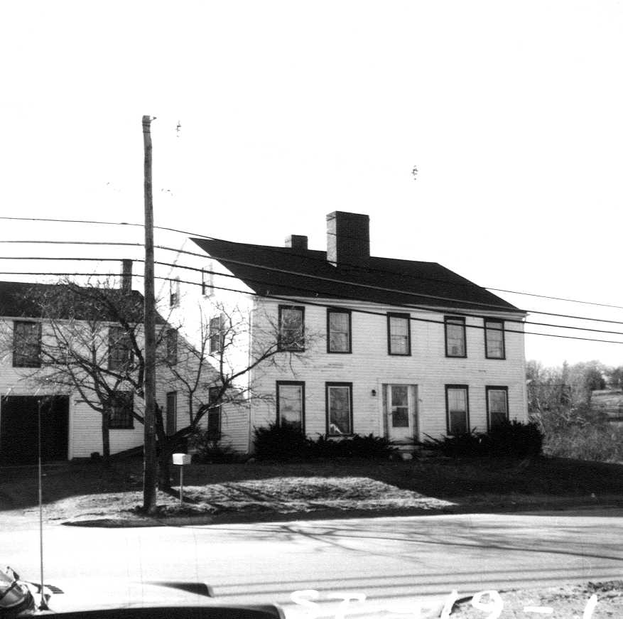
| Also Known As | Josiah Crosby House |
| Address | 581 Boston Rd |
| MACRIS ID | BIL.198 |
| Built | 1700 |
| Demolished | 1987 |
| Owners | Josiah Crosby II (1822 - 1829) |
The Fiske Tavern Stand stood on the southwest side of Boston Road opposite the end of Webb Brook Road, near Mason's Corner, where a gas station now stands at 581 Boston Road. It was a low, early house with a feature found nowhere else in Billerica: two separate chimneys set "fore-and-aft" instead of one great central chimney, perhaps because a rear chimney was added when an older, smaller house was enlarged. The second floor of the ell had a ballroom with a "sprung" floor. The Billerica Historic Commission surveyor who recorded it in 1974 thought its setting and its placement "low to ground" suggested the 17th century.
The land was the homestead of the Kittredge family. John Kittredge, the first settler of the name, had his house lot "on ye south-east of bare hill, on ye west side of the country road," about a mile southeast of the village, and when his son Dr. John Kittredge died in 1714 the inventory began with "The homestead about fifty acres of land and medow with the buildings upon it." No deed of the next sale was recorded, but by 1738 the homestead belonged to Lt. John Wilson, son of the builder of the corn mill on Vine Brook. On May 10, 1738 he and his wife Elizabeth (Foster) sold their son Jacob Wilson, a carpenter, the southerly half "of our homestead which was formerly John Kittredges," "with the building thereon," bounded easterly on the County Road. In 1765 Jacob Wilson sold about 38 acres "with all the Buildings Edifices Fences Trees" to Oliver Crosby and Josiah Crosby, and on Feb. 22, 1768 Josiah released to Oliver "Twenty acres and ninety five poles with all the buildings thereon," "the house lot yt was Jacob Willsons."
Oliver Crosby, later a deacon, kept the place until his death in 1822 and left it by will to his son Josiah Crosby Esq., a town leader and trustee of the Billerica Academy, who died in 1829 and left everything to his wife Betsy. When Betsy Crosby's estate was appraised on June 1, 1832, the first item was "The Homestead farm with all the buildings, including the Tavern stand & 8 acres of land," with hay stored "in the tavern barn": the house was already a tavern stand under the Crosbys. Dr. Zadok Howe, guardian of the Crosbys' young son Josiah, advertised "The large, handsome, and commodious mansion House, with numerous and convenient out houses, and Barns, with 21 acres of Land of the first quality adjoining, lately owned and occupied by Josiah Crosby, Esq. deceased, situate about a mile from Billerica Meeting-house, on the road to Boston," and on April 9, 1833 sold it at auction to John Baldwin and Henry Baldwin, who deeded it to Howe himself the same day. On Oct. 22, 1833 Howe sold the homestead for $2,769.79 to Sereno Fiske of Weston.
Fiske kept the tavern for about ten years and then moved west. In January 1844, living in Southport in the Wisconsin Territory, he sold "the said Fisk's Tavern stand, so called," nine acres 70 rods "with the buildings thereon," to Moses P. Greenwood for $3,200, and in 1848 Greenwood sold it to Lowell F. Jennison as the place "formerly called the Crosby Tavern Stand." From then on every deed bounded the lot the same way: from the Boston Road at Hervey Crosby's land westerly to "the first cross wall running south," then south along that wall 34 rods 18 links, and back east to the road. Jennison sold to Haslet Mackay by a deed of May 18, 1856 that was never recorded; it is known from Mackay's own later deed, and in 1857 the mortgage Jennison had given was discharged to Mackay. Mackay is the "H. McKay" of the 1875 map. In 1884 he deeded "my Homestead ... with the buildings thereon" to his stepson Edward B. Haskell, the "A. Haskell" of the 1889 map, who sold it in 1907 to Arthur W. Merriam and Charles E. Moore.
John E. Farmer bought the place from Merriam and Moore in 1913, and in 1929 the Land Court registered it to him as land running about 620 feet along Boston Road, his address given as "Boston Rd., opp Webb Brook Rd." A strip along the front was taken in the early 1930s for the widening of Boston Road (Lot A of the 1932 plan), leaving Lot B, which Farmer and his wife Bertha took as tenants by the entirety in 1943. In 1965 Lot B was divided: the rear Lot 2 went to the Cerretani Realty Trust, and the house, its ell and a barn stayed on Lot 1, drawn on the 1965 survey with 271.5 feet on Boston Road. Mary R. Farmer held Lot 1 from 1969, and in 1974 her heirs owned the house, then a two-family residence. The lot was sold in 1975 to Sousa Oil Company and in 1986 to Leemilt's Petroleum, Inc.; by 1987 the house had been demolished and replaced with a gas station. In 2016 the lot was sold to East Coast Commercial Real Estate, LLC, and in 2018 it passed to the 581 Boston Road Realty Trust.
References
- MACRIS BIL.198
- Hazen, History of Billerica (1883): John Kittredge's house lot SE of Bare Hill on the country road; the Wilson and Crosby families in the Genealogical Register
Title References
| Date | Type | Grantor | Grantee | Summary | Recorded |
|---|---|---|---|---|---|
| 1714 | Administration and Inventory | Estate of Doct. John Kittredge of Billerica (intestate) | Hannah Kittredge, widow, and John Kittredge, administrators; the heirs | Dr. John Kittredge's homestead "with the buildings", 1714 | Probate #13373 |
Dr. John Kittredge, son of the first settler, died in April 1714. His widow Hannah and son John gave bond as administrators on June 14, 1714. The inventory of May 17, 1714 (Samuel Walker, Joseph Davis, George Brown) begins "The homestead about fifty acres of land and medow with the buildings upon it," 200 pounds, followed by about 150 acres "northward of strong water brook," meadow on the Shawshin, land on Content Plain and west of the great river, and "half of a sawmill." Receipts of 1715-1716 from the estate's creditors follow. The house lot of the first John Kittredge was ten acres "on ye south-east of bare hill, on ye west side of the country road" (Hazen); by 1738 the Wilsons called this land "our homestead which was formerly John Kittredges." Papers read, pages 2-5.
|
|||||
| November 6, 1738 | Deed | Lt. John Wilson of Billerica and Elizabeth (Foster) Wilson his wife | Jacob Wilson of Billerica, carpenter, their son | half the Kittredge homestead to Jacob Wilson | 39/413 (South) |
Dated May 10, 1738, acknowledged May 19, recorded Nov. 6, 1738. For 500 pounds, one half "of our homestead which was formerly John Kittredges," the half "on the southerly side," "with the building thereon," bounded easterly on the County Road, southerly by Nathan Crosby, and westerly and northerly on John Parker; also five acres at Bare Hill. Billerica town book 4, pages 198-199 (Southern Registry Book 39 Page 413). This is the half that Jacob Wilson sold with "all the Buildings" to Oliver and Josiah Crosby in 1765.
Title passed to:
Related:
|
|||||
| 1765 | Warranty | Jacob Wilson of Billerica, husbandman | Oliver Crosby and Josiah Crosby, both of Billerica, husbandmen | Jacob Wilson sells the 38-acre place with its buildings to Oliver and Josiah Crosby | 71/353 (South) |
For 133 pounds 6 shillings 8 pence, "One Certain Lot or parcel of Land Situate and lying in Billerica aforesaid Containing about Thirty eight acres of Land be the same more or less with all the Buildings Edifices Fences Trees timber and Stones thereon standing," bounded easterly by "the County Road Leading from Billerica to Woburn," southerly and eastwardly by the Crosbys' own land, southerly by the road leading to Hezekiah Crosby's, westerly partly by the highway to Bedford and partly by the heirs of John Blanchard, and northwardly by Capt. Daniel Stickney's land, to the Crosbys and their heirs equally. MACRIS dates the deed June 25, 1765. Billerica town book 6, pages 454-456 (Southern Registry Book 71 Page 353). Jacob Wilson held the land as half of his father John Wilson's homestead, "formerly John Kittredges," under the deed of May 10, 1738 (town book 4/198); in 1768 Josiah Crosby released his share, including "the house lot yt was Jacob Willsons," to Oliver Crosby (town book 6/457). Both deeds are rows of their own.
Title from:
Title passed to:
|
|||||
| April 12, 1771 | Quitclaim | Josiah Crosby of Billerica, husbandman | Oliver Crosby of Billerica, husbandman | Josiah Crosby releases "the house lot yt was Jacob Willsons" to Oliver Crosby | 71/354 (South) |
Dated Feb. 22, 1768, acknowledged Nov. 21, 1770, recorded April 12, 1771. For 133 pounds 6 shillings 8 pence, Josiah releases to Oliver his share of the land they had bought together from Jacob Wilson, first "Twenty acres and ninety five poles with all the buildings thereon," "the house lot yt was Jacob Willsons," bounded easterly on the County Road leading to Woburn, southeasterly by the house lot of Oliver Crosby late of Billerica deceased, westerly on Josiah's meadow and northwesterly by Capt. Daniel Stickney; also lots of 9 acres, 9 acres 62 poles, 5 acres 101 poles and 14 3/4 acres (the Gookin lot). Billerica town book 6, pages 457-458 (Southern Registry Book 71 Page 354). From this deed the house lot was Oliver Crosby's.
Title from:
Title passed to:
|
|||||
| 1825 | Will | Deacon Oliver Crosby Esq. of Billerica | Josiah Crosby Esq., his son and executor | will of Oliver Crosby Esq.: residue to his son Josiah | Probate #5363 |
Will dated Jan. 13, 1821; Oliver Crosby died March 17, 1822 and the will was allowed Nov. 8, 1825. After legacies to his wife Rachel and his other children, he left the rest of his real and personal estate to his son Josiah Crosby Esq., whom he named executor. Oliver had held the Wilson house lot since 1768; it came to Josiah under this will. Papers read, pages 2-5.
Title from:
Title passed to:
|
|||||
| 1829 | Will | Josiah Crosby Esq. of Billerica | Betsy Crosby, his widow | will of Josiah Crosby Esq.: residue to his widow Betsy | Probate #5353 |
Will dated June 6, 1829, allowed Aug. 11, 1829. After provision for his mother Rachel and legacies to his children Elizabeth H. Whitman, Oliver, Susannah, Sarah C., Martha and Josiah, Josiah Crosby Esq. left the rest of his estate, real and personal, to his wife Betsy "in fee simple." Joseph Locke was later made administrator de bonis non (Aug. 21, 1832). Papers read, pages 1-8.
Title from:
Title passed to:
|
|||||
| 1832 | Will and Inventory | Betsy Crosby of Billerica, widow of Josiah Crosby Esq. | Susanna Crosby and Josiah Crosby (a minor), her children; Joseph Locke, executor | will and inventory of Betsy Crosby: "including the Tavern stand" | Probate #5333 |
Will dated Aug. 12, 1831, allowed June 5, 1832; Joseph Locke executor. After other legacies the residue went to her daughter Susanna and her son Josiah. The inventory taken June 1, 1832 values "The Homestead farm with all the buildings, including the Tavern stand & 8 acres of land, the Slaughter house lot, the Richardson land, the Webb orchard & the Lawson house & land" at $7,585, and lists hay "in the tavern barn": the house was already known as a tavern stand before Sereno Fiske bought it. Papers read, pages 2-17.
Title from:
Title passed to:
|
|||||
| 1833 | Guardianship and License to Sell | Josiah Crosby, minor, son of Josiah Crosby Esq. | Dr. Zadok Howe, his guardian | guardianship of Josiah Crosby, minor; auction bill of the mansion house | Probate #5354 |
Zadok Howe gave bond as guardian of the minor Josiah Crosby on May 15, 1832, with John Baldwin and Joseph Locke as sureties. The papers include the printed auction bill of Feb. 19, 1833: "The large, handsome, and commodious mansion House, with numerous and convenient out houses, and Barns, with 21 acres of Land of the first quality adjoining, lately owned and occupied by Josiah Crosby, Esq. deceased, situate about a mile from Billerica Meeting-house, on the road to Boston," the sale "to commence at the Mansion House." The sale was made under a license of the Supreme Judicial Court (October term, 1832). Papers read, pages 2-5.
Title from:
Title passed to:
Related:
|
|||||
| April 22, 1833 | Guardian's Deed | Dr. Zadok Howe of Billerica, guardian of Josiah Crosby, minor | John Baldwin Esq. and Henry Baldwin, gentleman, both of Billerica | guardian's auction deed to the Baldwins | 322/316 (South) |
Dated April 9, acknowledged April 18, recorded April 22, 1833. Under the license of the Supreme Judicial Court (October term, 1832), after public auction on April 2 and 9, 1833, for $2,557.15 to the highest bidders, "the homestead place of Josiah Crosby Esquire late of Billerica deceased," 21 acres 23 rods "with the buildings thereon," bounded easterly on the highway from Billerica to Boston, southerly and westerly by Michael Crosby Jr. and northerly by land formerly of Benjamin Bowers; also the schoolhouse lot of 8 acres 38 rods, half the Fox Hill (Rowland) lot, the Frost pasture of 26 acres 38 rods and a pew. Billerica town book 16, pages 233-235 (Southern Registry Book 322 Page 316). The same day the Baldwins deeded the homestead and schoolhouse lot to Howe himself (Southern Registry Book 325 Page 559), a straw sale that let the guardian buy.
Title from:
Title passed to:
Related:
|
|||||
| October 25, 1833 | Warranty | John Baldwin Esq. and Henry Baldwin, gentleman, both of Billerica, with Clarissa and Anne their wives | Zadok Howe of Billerica, Esq. | The Baldwins convey the late Josiah Crosby's homestead to Zadok Howe | 325/559 (South) |
For $2,219.79, "a tract of land situate in said Billerica containing twenty one acres and twenty three rods with the buildings thereon standing it being the homestead place of the late Josiah Crosby Esquire," also eight acres 38 rods "called the school house lot," "as both said tracts or parcels are described in the said Howe's deed to us of even date herewith." Dated April 9, acknowledged April 18 before Marshall Preston, recorded Oct. 25, 1833. Billerica town book 16, pages 288-289 (Southern Registry Book 325 Page 559). The Baldwins had bought the homestead the same day at the auction held by Zadok Howe as guardian of the minor Josiah Crosby (Southern Registry Book 322 Page 316); this deed passed it to Howe himself.
Title from:
Title passed to:
Related:
|
|||||
| October 28, 1833 | Warranty | Zadok Howe of Billerica, Esq. | Sereno Fiske of Weston, yeoman | Zadok Howe sells the Crosby homestead to Sereno Fiske | 325/578 (South) |
For $2,769.79, "the homestead place of the late Josiah Crosby Esquire late of said Billerica deceased containing twenty one acres and twenty three rods more or less," beginning at the southeasterly corner at the Boston road and land of Michael Crosby Jr., westerly by Michael's land 80 rods 14 links, northerly by him 32 rods 4 links to land formerly of Benjamin Bowers, easterly by Bowers "by the wall as it now stands" 51 rods 35 links to land of Oliver Crosby, still easterly by Oliver 33 rods 15 links, southeasterly by the wall 7 rods 3 links to the Boston road, and by the road to the first corner; also the 8-acre schoolhouse lot bounded easterly by the road from Michael Crosby's homestead to Joseph Blanchard's, southerly by Michael's "Tuggins lot," westerly by Michael and northerly by the road from Michael's dwelling house to the Lexington road, "according to a survey and plan of the premises made by S. Livingston dated November 1832." Dated and acknowledged Oct. 22, recorded Oct. 28, 1833. Billerica town book 16, pages 289-290 (Southern Registry Book 325 Page 578). Fiske sold the schoolhouse lot to Michael Crosby Jr. in 1834 (town book 13/580) and a strip on the north, the "Tavern Stand Lot," to Hervey Crosby in 1842 (town book 17/378). Neither of those parcels held the house.
Title from:
Title passed to:
|
|||||
| July 13, 1844 | Warranty | Sereno Fiske, formerly of Billerica, now of Southport in the Wisconsin Territory, by Marshall Preston his attorney | Moses P. Greenwood of Billerica, yeoman | Fiske sells "Fisk's Tavern stand" to Moses P. Greenwood | 445/401 (South) |
For $3,200, "the following several lots of real estate situate in said Billerica viz. The said Fisk's Tavern stand, so called, containing nine acres and seventy rods more or less, with the buildings thereon," beginning at the northeasterly corner at the Boston road and land of Hervey Crosby, westerly by Crosby to the first cross wall running south, southerly by that wall 34 rods 18 links by Fiske's land to the first stone wall running easterly, easterly by that wall to the Boston road and northerly by the road to the beginning; also the Webb Orchard and Richardson land (17 acres 69 rods) on the Boston road by Samuel A. Rogers, Haslet Mackay, the Isaac Pollard farm and Joseph White; the Stoney pasture and Fuller land (30 acres) by the road from the Great Boston road to the Middlesex Turnpike; and the Crosby pasture (20 acres) by Joseph Blanchard and the Bowers Ross lot. Dated Jan. 16, acknowledged Jan. 18, recorded July 13, 1844. Billerica town book 17, pages 501-502 (Southern Registry Book 445 Page 401). Preston quitclaimed the same lots the same day to release the dower of Fiske's wife (town book 17/503, S. 445/402). Greenwood also gave George Bacon a mortgage of the tavern stand that year (town book 16/457), before selling to Jennison in 1848.
Title from:
Title passed to:
|
|||||
| April 12, 1848 | Mortgage | Lowell F. Jennison of Billerica, yeoman | George Bacon of Billerica, yeoman | Jennison's mortgage of the Crosby Tavern Stand | 534/88 (South) |
For $1,000, "a certain tract of land with the buildings thereon situate in said Billerica formerly called the Crosby Tavern stand containing nine acres and seventy rods," bounded from the Boston road at Hervey Crosby's land westerly to the first cross wall running south, southerly by that wall 34 rods 18 links by Josiah B. Gleason, easterly by Gleason to the road; given the day Jennison bought from Greenwood. Billerica town book 20, pages 43-44 (Southern Registry Book 534 Page 88). Bacon assigned it to Lyman Haynes in 1856, and Haynes discharged it to Haslet Mackay in 1857.
Related:
|
|||||
| 1848 | Warranty | Moses P. Greenwood of Billerica, yeoman, and Lucy Greenwood his wife | Lowell F. Jennison of Billerica, yeoman | Greenwood sells the "Crosby Tavern Stand" to Lowell F. Jennison | 534/91 (South) |
For $1,550, "a certain parcel of land situate in said Billerica with the buildings thereon formerly called the Crosby Tavern Stand containing nine acres and seventy rods more or less," beginning at the northeasterly corner at the Boston road and land of Hervey Crosby, westerly by Crosby to the first cross wall running south, southerly by that wall 34 rods 18 links by land of Josiah B. Gleason, easterly by Gleason to the Boston road and northerly by the road to the beginning. Dated April 1, acknowledged April 8, 1848. Billerica town book 20, page 45 (Southern Registry Book 534 Page 91). Jennison mortgaged the tavern stand to George Bacon for $1,000 the same day (town book 20/43, Southern Registry Book 534 Page 88, a row of its own) and gave a second mortgage to Greenwood in 1854 (town book 20/484). He sold the place to Haslet Mackay by a deed of May 18, 1856 that was never recorded; it is recited in Mackay's 1884 deed to Edward B. Haskell (Middlesex North Book 221 Page 259). The 1853 map shows L. F. Jennison here, the 1875 map H. McKay and the 1889 map A. (Edward B.) Haskell.
Title from:
Title passed to:
|
|||||
| 1856 | Assignment of Mortgage | George Bacon of Billerica | Lyman Haynes of Billerica | assignment of the Jennison mortgage | 7/387 |
Dated Dec. 16, 1856. Bacon assigns to Lyman Haynes the mortgage of the Crosby Tavern Stand given by Lowell F. Jennison in 1848 (Southern Registry Book 534 Page 88), with the note it secured. By then Jennison had sold the place to Haslet Mackay.
Related:
|
|||||
| July 9, 1857 | Discharge of Mortgage | Lyman Haynes of Billerica, assignee of the mortgage | Haslet Mackay of Billerica | mortgage discharged to Haslet Mackay | 10/521 |
Dated and acknowledged June 2, 1857 before Dudley Foster, recorded July 9, 1857. Haynes, "to whom this Mortgage was assigned," acknowledges that he has "received of Haslet Mackay ... full satisfaction" of the Jennison mortgage and releases "to the said Mackay" all right in the premises; the margin notes the mortgage itself at Cambridge, Book 534 Page 88. The discharge runs to Mackay because he then owned the tavern stand.
Related:
|
|||||
| January 13, 1891 | Quitclaim | Haslet Mackay of Billerica | Edward B. Haskell of Billerica | Haslet Mackay to Edward B. Haskell | 221/259 |
Dated and acknowledged Nov. 11, 1884 before Dudley Foster, recorded Jan. 13, 1891. For $5 and other consideration, "my Homestead, situated in said Billerica with the buildings thereon, containing nine acres & twenty rods," beginning at the northeasterly corner at the Boston Road and land of Harvey (Hervey) Crosby, westerly by Crosby to the first cross wall running south, southerly by the wall 34 rods 18 links by David L. Mason, easterly by Mason to the Boston Road: "Being real estate conveyed to me by Lowell F. Jennison deed dated May 18th 1856" (that deed was never recorded). Also the Carr Place of 11 acres on the opposite side of Boston Road (from Nancy Noyes, 1874), 21 acres on the back road from the Seth Heaton place (from John Crosby, 1858) and 12 acres at Shawsheen Bridge (from Josiah B. Gleason, 1865). Haskell's 1907 deed says Mackay's wife, Haskell's mother, died in Mackay's lifetime.
Title from:
Title passed to:
Related:
|
|||||
| 1907 | Quitclaim | Edward B. Haskell of Billerica, widower | Arthur W. Merriam and Charles E. Moore, both of Billerica | Haskell to Merriam and Moore | 401/139 |
Dated March 5, 1907. "A certain lot of land with the buildings thereon situated in said Billerica containing nine acres and seventy square rods," bounded as in the Mackay deed, from the Boston Road at land now or formerly of Harvey Crosby to the first cross wall running south, 34 rods 18 links by David L. Mason; "the first lot described in a deed to me from Haslet Mackay" (Middlesex North Book 221 Page 259). The margin of the companion mortgage refers forward to the 1929 assignments (Book 775 Page 110) and to Land Court Certificate 3844.
Title from:
Title passed to:
|
|||||
| 1907 | Mortgage | Arthur W. Merriam and Charles E. Moore, both of Billerica | Edward B. Haskell of Billerica | Merriam and Moore mortgage to Haskell | 401/140 |
Dated March 5, 1907, the same day as Haskell's deed to them. The same 9 acres 70 square rods "with the buildings thereon" at the Boston Road, "intending hereby to convey ... all the same premises conveyed to us by said Edward B. Haskell by his deed of even date," to secure $3,000 in one year at five per cent, the buildings to be insured for not less than $2,300. John E. Farmer assumed this mortgage in 1913 and it was still open when the land was registered in 1929.
Related:
|
|||||
| December 1, 1913 | Quitclaim | Arthur W. Merriam and Charles E. Moore of Billerica, with Olive M. Merriam and Estella M. Moore their wives | John E. Farmer of Billerica | Merriam and Moore to John E. Farmer | 514/549 |
Dated Nov. 29, recorded Dec. 1, 1913. For one dollar and other consideration, "a certain lot of land with the buildings thereon situated in said Billerica containing nine acres and seventy square rods," from the Boston Road at land now or formerly of Harvey Crosby to the first cross wall running south, 34 rods 18 links by David L. Mason: "Being the same premises as conveyed by Edward B. Haskell to us ... by deed dated March 5, 1907, and recorded with Middlesex North District Deeds, book 401, page 139." Farmer assumed the $3,000 Haskell mortgage (book 401, page 140), with interest from Sept. 5, 1913 and the taxes for 1912 and 1913.
Title from:
Title passed to:
|
|||||
| August 22, 1929 | Land Court Decree | Land Court, on the petition of John E. Farmer (case 13473) | John E. Farmer of Billerica, married to Bertha S. Farmer | Land registered to John E. Farmer | Ctf 3844 |
Original Certificate of Title 3844, entered on the decree of Aug. 21, 1929 in case 13473: land in Billerica bounded "Northeasterly by Boston Road six hundred nineteen and 59/100 (619.59) feet," southeasterly and southwesterly by land of Franklin L. Mason about 585 and 575 feet, and northwesterly by land of Delia C. Crosby, as shown on a plan by E. P. Sellew dated June 12, 1928; subject to a mortgage given by Arthur W. Merriam and others to Edward B. Haskell dated March 5, 1907, assigned to Mary E. Clark in 1913. "Owner's Address: Boston Rd., opp Webb Brook Rd." Received at Lowell Aug. 22, 1929. In 1932-34 Lot A of plan 13473-B, a strip about 620 feet long along Boston Road, went to the Commonwealth for the widening of the road (Certificate 4615, registered June 22, 1934), leaving Lot B.
Title from:
Title passed to:
Related:
|
|||||
| April 13, 1929 | Assignment of Mortgage | Mary E. Taber, executrix under the will of Edward B. Haskell; Florence M. Orrill | Florence M. Orrill of Newton; Mary E. Taber of Sherborn | assignments of the Haskell mortgage | 775/110 |
Two assignments dated April 10, 1929, recorded April 13, 1929: Mary E. Taber, executrix of Edward B. Haskell, assigns the Merriam and Moore mortgage of March 5, 1907 (book 401, page 140) to Florence M. Orrill, and Orrill assigns it back to Taber "without recourse." Four months later the Land Court registered the land to John E. Farmer subject to this mortgage (Certificate 3844).
Related:
|
|||||
| June 22, 1934 | Certificate of Title | John E. Farmer (from Original Certificate 3844, registered Aug. 22, 1929) | The Commonwealth of Massachusetts | Boston Road frontage (Lot A) to the Commonwealth | Ctf 4615 |
Partial Transfer Certificate of Title 4615, entered June 22, 1934: the strip along the front of the Farmer land taken for the widening of Boston Road, bounded "Northeasterly by Boston Road, six hundred nineteen and 59/100 (619.59) feet," southeasterly by Franklin L. Mason 0.06 foot, "Southwesterly by Lot B, six hundred eighteen and 49/100 (618.49) feet," and northwesterly by Delia C. Crosby 2.03 feet: Lot A on Land Court subdivision plan 13473-B, drawn by Arthur Larrabee, Office Engineer, dated July 20, 1932, a copy of which is filed with this certificate. Owner's address: Boston. The house stood on the remaining Lot B.
Title from:
|
|||||
| June 26, 1943 | Certificate of Title | John E. Farmer (from Certificate 3844) | Doris Stevens of Lowell, not married | Lot B, 1943 | Ctf 6267 |
Partial Transfer Certificate of Title 6267, entered June 26, 1943 at 10 o'clock: Lot B of plan 13473-B, bounded "Northeasterly by the southwesterly line of Boston Road, six hundred eighteen and 49/100 (618.49) feet," southeasterly by Franklin L. Mason 584.94 feet, southwesterly by Mason about 575 feet and northwesterly by Delia C. Crosby about 883.97 feet. Owner's address 174 Central St., Lowell. Cancelled the same morning by Certificate 6268 to John E. and Bertha B. Farmer: a conveyance through a third person to create a tenancy by the entirety.
Title from:
Title passed to:
|
|||||
| June 26, 1943 | Certificate of Title | Doris Stevens (from Certificate 6267) | John E. Farmer and Bertha B. Farmer of Billerica, husband and wife, tenants by the entirety | Lot B to John E. and Bertha B. Farmer | Ctf 6268 |
Transfer Certificate of Title 6268, entered June 26, 1943 at 10:01: the same Lot B of plan 13473-B, 618.49 feet on the southwesterly line of Boston Road. Owners' address: Boston Rd., R. F. D. #1, opposite Webb Brook, Billerica. A marginal note records that Lot B was divided by plan 13473-C (1965); Lot 2 went out on Certificate 14356, and Lot 1 with the house later passed to Mary R. Farmer (Certificate 16941, 1969).
Title from:
Title passed to:
|
|||||
| May 20, 1965 | Certificate of Title | John E. and Bertha B. Farmer (from Certificate 6268) | Trustees of the Cerretani Realty Trust (Declaration of Trust dated March 3, 1965, Document 44080), of Melrose | Lot 2 split off 1965; house on Lot 1 | Ctf 14356 |
Partial Transfer Certificate of Title 14356, entered May 20, 1965: Lot 2 of Land Court subdivision plan 13473-C (E. Conrad Levy and Associates, surveyors, Feb. 1, 1965), the large rear and northwesterly part of Lot B, 346.99 feet on Boston Road, bounded by Lot 1, Franklin L. Mason and Delia C. Crosby. The plan filed with this certificate draws the old house, its ell and a barn on Lot 1 (271.50 feet on Boston Road, 139.22 feet on Mason), which the Farmers kept.
Title from:
|
|||||
| August 22, 1969 | Certificate of Title | John E. and Bertha B. Farmer (Certificate 6268, registered 1943) | Mary R. Farmer of Billerica, not married | Lot 1 with the house to Mary R. Farmer | Ctf 16941 |
Transfer Certificate of Title 16941, registered Aug. 22, 1969: Lot 1 on Land Court subdivision plan 13473-C, drawn by E. Conrad Levy & Associates, surveyors, dated Feb. 1, 1965 (the plan divided Lot B of plan 13473 into Lots 1 and 2), bounded northeasterly by the southwesterly line of Boston Road 271.50 feet, southeasterly by land of Franklin L. Mason 139.22 feet, southwesterly 299.04 feet and northwesterly 135.32 feet by Lot 2. MACRIS recorded the owner in July 1974 as "heirs of Mary R. Farmer," the house then being a two-family residence.
Title from:
Title passed to:
|
|||||
| April 22, 1975 | Certificate of Title | Estate of Mary R. Farmer (from Certificate 16941) | Sousa Oil Company, Inc., of Danvers | Sold to Sousa Oil Company | Ctf 20773 |
Transfer Certificate of Title 20773, registered April 22, 1975: the same Lot 1 of plan 13473-C, 271.50 feet on Boston Road, to Sousa Oil Company, Inc., a Massachusetts corporation of 29 Andover St., Danvers.
Title from:
Title passed to:
|
|||||
| December 4, 1986 | Certificate of Title | Sousa Oil Company, Inc. (from Certificate 20773) | Leemilt's Petroleum, Inc., a New York corporation of Plainview, N.Y. | To Leemilt's Petroleum; house demolished by 1987 | Ctf 27525 |
Transfer Certificate of Title 27525, dated Dec. 4, 1986: Lot 1 of plan 13473-C, bounded as in 1969 and 1975. The old house was gone by 1987 and a gas station was built on the lot (the present footprints date from about 1996; a variance and permit were registered April 29, 1996). On March 7, 2016 Leemilt's Petroleum sold the lot for $120,000 to East Coast Commercial Real Estate, LLC, of Biddeford, Maine (Doc. 285983, Certificate 42702). In 2018 the lot passed to the trustee of the 581 Boston Road Realty Trust (Certificate 43797).
Title from:
Title passed to:
|
|||||
| March 7, 2016 | Certificate of Title | Leemilt's Petroleum, Inc. (from Certificate 27525) | East Coast Commercial Real Estate, LLC, of Biddeford, Maine | Lot 1, 2016 | Ctf 42702 |
Transfer Certificate of Title 42702, registered March 7, 2016 (deed registered as Document 285983): Lot 1 of plan 13473-C, "Northeasterly by the Southwesterly line of Boston Rd., two hundred seventy-one and 50/100 (271.50) feet," southeasterly by Franklin L. Mason 139.22 feet, southwesterly 299.04 feet and northwesterly 135.32 feet by Lot 2. Cancelled in 2018 by Certificate 43797.
Title from:
Title passed to:
|
|||||
| 2018 | Certificate of Title | East Coast Commercial Real Estate, LLC (from Certificate 42702) | Trustee of the 581 Boston Road Realty Trust (Declaration of Trust dated March 30, 2018, Document 295879) | Lot 1, 2018 | Ctf 43797 |
Transfer Certificate of Title 43797 (Registration Book 222, Page 20; the deed is Document 296878): the same Lot 1 of plan 13473-C, 271.50 feet on Boston Road, to the trustee of the 581 Boston Road Realty Trust, of Billerica. The trustee, a private individual, is not named here. The lot is the gas station site at 581 Boston Road.
Title from:
|
|||||
Recorded is Book/Page at the Middlesex North Registry of Deeds unless noted; Probate # is a Middlesex probate case, Ctf a Land Court certificate of title.