Patten Homestead
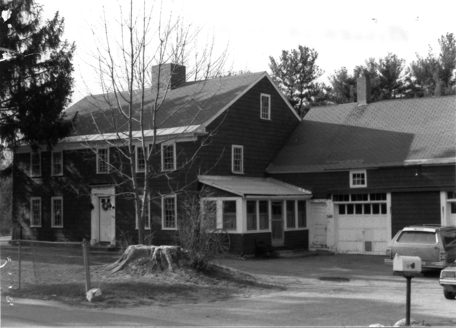
The Patten Homestead stands close to Salem Road (Route 129) in East Billerica, just south of the line of the Middlesex Canal and a short way west of Pattenville and the canal's aqueduct over the Shawsheen River. When the Historical Commission examined it in 1989 it was judged "the only 'First Period' house in Billerica so identified by tangible interior evidence": the two front rooms have exposed, chamfered and decorated framing and unplastered ceilings, and the architectural historian Anne Grady dated the decoration of the beams and the spacing of the joists to about 1700. One summer beam has a collar carved into a chevron that she found "unlike anything else known in New England." The house began as a two and a half story hall and parlor house around a central chimney; a lean-to was added across the back and later raised to two full stories under a single gable roof. It was listed with the Billerica National Register district in 2009.
Who built it is not settled, and the deeds do not name a builder. The land lay in the "Web lot" of the second division, which Simon Crosby held in 1691; no record shows how it came to the Pattens. It was theirs by 1718, when the inventory of Nathaniel Patten (1668-1718), son of Thomas Patten of the Content Brook saw mill, listed besides his Allen Road homestead "about ninety acres of upland and meadow at Shawshin River." In 1733 his widow, remarried to Joseph Emerson of Haverhill, settled her thirds with her sons Nathaniel and John Patten, who had "agreed upon a line between themselves" at the Shawsheen, and that May Nathaniel sold John eighteen acres of upland and swamp "on the Easterly part of the Town," bounded by Capt. George Brown, John Baldwin Jr. and "said Pattens own land." Charles E. Stearns of the Historical Commission thought Nathaniel the most likely builder; the evidence fits either him or the brothers' division. The first sign of the house itself is a highway order of 1743 that mentions "John Patten's house."
By his will of May 1785 John Patten left his wife Jane two cows "and the use of a horse to Ride to meeting," gave his older son John twenty pounds as his "full part," and left "unto my Son Asa Patten all my Estate." When the Middlesex Canal was laid out, Asa Patten sold its Proprietors on Jan. 2, 1800 "a strip of land thro' said Pattens farm north of his house about eighty two & a half rods in length & eight rods in breadth," with half an acre by the aqueduct, the earliest deed that places the house. Asa died without a will in 1817, "leaving no widow nor children excepting" Polly, the wife of Theophilus Manning; his inventory begins with "the home farm first lot about seven acres with the buildings thereon." Manning (1777-1868) had married two of Asa's daughters in turn, Hannah in 1807 and then Polly, and so the homestead passed to the Mannings. He was a man of some means, for a time holding the grist mill at Pattenville, and in January 1852, when the canal was closing, the Proprietors sold him their land around the farm: the strip "through the said Mannings farm (formerly Pattens) North of his house," the Kendall land by the road, and Beard's mill lot at the aqueduct, on condition that he take down Kendall's bridge over the canal. The painted scenes of trees, water and mountains on the walls of the front room, which a conservator in 1989 dated to the 1820s or 1830s, belong to the Manning years; local tradition remembered a stage coach in them.
Theophilus Manning died on June 30, 1868. His will of 1833 left everything to his wife Polly, and on March 29, 1869 she gave the homestead north of the road, about seventy acres "with the buildings thereon," to their daughters Hannah P. Chandler, a widow, and Polly Manning, and the land south of the road to their son William. Neither daughter sold it. Polly died in 1874 and Hannah in 1889, and on Feb. 16, 1914 the family heirs (William Manning's devisees, a granddaughter and the children of Theophilus Manning Jr.) sold the farm to Mary A. Hopkinson, wife of Isaac Hopkinson, ending about two centuries in the Patten and Manning families. In 1942 Mary Hopkinson, then a widow, gave the house and farm, with the old canal bed and towpaths, to her daughter Doris H. Dignon, keeping out a parcel for her son Raymond. The house lot was drawn as Lot 2 on a 1965 plan, 55,240 square feet between Salem Road and the canal, and after the deaths of Doris and Frank T. Dignon the executor of his will sold it in 1988 to a private owner, who uncovered the murals and invited the Historical Commission and the Society for the Preservation of New England Antiquities to study the house.
References
- MACRIS BIL.152
- Middlesex County Probate File Papers, 1648-1871: Patten estates (cases 16995, 17007, 17020) and Theophilus Manning (case 36944)
- Hazen, History of Billerica (1883): the Patten family and Pattenville
Title References
| Date | Type | Grantor | Grantee | Summary | Recorded |
|---|---|---|---|---|---|
| 1718 | Administration, Inventory and Dower Agreement | Estate of Nathaniel Patten of Billerica (1668-1718), intestate | Hannah Patten, widow and administratrix (later Hannah Emerson), and their sons Nathaniel and John Patten | Nathaniel Patten's estate: ninety acres at Shawshin River divided by his sons | Probate #17020 |
Nathaniel Patten died early in 1718. On May 12, 1718 his widow gave bond as administratrix, with Thomas Patten and Thomas Ross. The inventory taken April 23, 1718 by Ephraim Kidder, Enoch Kidder and George Brown lists "the homestead about fifty acres of upland and meadow with the buildings" at 240 pounds; thirty-one acres "part of the first lot in the first part of the 2d division"; four acres on Rocky Hill; "about ninety acres of upland and meadow at Shawshin River" at 140 pounds; a hundred acres at Heath Swamp; thirty-one acres on Recompense Plain; thirty-two acres west of the great river; and swamp lots; with a weaver's loom among the goods. On May 18, 1733 Hannah Emerson, "the Relict Widow of Nathaniel Patton," then wife of Joseph Emerson of Haverhill, agreed with her sons Nathaniel and John Patten on her thirds: "the West end of the Dwelling house throughout," the west end of the barn, most of the orchard south of the house and the pasture from "William French southwest corner of his Houselot (which is a Great Rock by the Highway)," part of the field east of the house by John Marshall, "Six Acres of medow at Shawshin River, lying on the Westerly side of the River ... where the two sons agreed upon a line between themselves," and the Recompense Plain lot; acknowledged May 21 and Oct. 19, 1733 and recorded at the court's order (lib. 19, pp. 392-393). The fifty-acre homestead with William French and John Marshall as neighbours was on Allen Road, not Salem Road; the ninety acres at Shawshin River, divided by the two sons, is where the Salem Road house stands, and the eighteen acres Nathaniel sold John the same month (town book 3, pages 451-453) adjoined "said Pattens own land." Middlesex probate case 17020.
|
|||||
| October 19, 1733 | Deed | Nathaniel Patten Jr. of Billerica, husbandman | His brother John Patten of Billerica | Nathaniel Patten Jr. sells his brother John eighteen acres adjoining John's own land | 35/163 (South) |
For 36 pounds paid "by my brother John Patten of Billerica," warranty deed of "One Tract of upland and swamp situate and lying in Billerica aforesaid containing by estimation Eighteen acres be it more or less on the Easterly part of the Town," bounded "by the land of Capt George Brown on the north, on the west by the land of John Baldwin Junr, one the South and East by said Pattens own land"; the north corner a small white oak with stones about it, the west corner a swamp white oak marked, the south and east corners stakes and stones; "excepting a highway upon it." Dated May 21, 1733 (6 Geo. II), witnessed by John Tarbol Jr. and Thomas Hosly, recorded at Cambridge Oct. 19, 1733. Captain George Brown was a partner in the Content Brook saw mill at Pattenville, and the Baldwins held land north of Salem Road, so this is the east-side land of the brothers' division of their father's Shawsheen River land, adjoining the part John already held. Billerica town book 3, pages 451-453 (also indexed under Tewksbury).
Title passed to:
Related:
|
|||||
| September 14, 1785 | Will | John Patten of Billerica, yeoman | Asa Patten, his son | John Patten's will: all his estate to his son Asa | Probate #17007 |
Will dated May 12, 1785: to his "Well Beloved Wife Jane Patten two Cows to be kept for her own improvement and the use of a horse to Ride to meeting," to his son John Patten twenty pounds "which is his full part of portion out of my Estate," to his granddaughter Hannah Kittredge twenty six pounds at eighteen, and "unto my Son Asa Patten all my Estate Both Real personal or mixed to him and his Heirs forever," Asa sole executor. Witnesses Reuben Kendall, Thomas Allen and Ephraim Crosby. Proved before Judge Oliver Prescott at Concord, Sept. 14, 1785. No inventory is in the file. Charles E. Stearns concluded that this is how Asa came to the house on Salem Road. Middlesex probate case 17007.
Title from:
Title passed to:
|
|||||
| November 11, 1801 | Warranty Deed | Asa Patten of Billerica, yeoman | The Proprietors of the Middlesex Canal | Asa Patten sells the canal a strip through his farm north of his house | 143/121 (South) |
For $247.45, "two certain pieces of land situate in northeasterly part of Billerica": the first "about four acres & twenty poles," bounded northwesterly on Samuel Brown's land, northerly or northeasterly by other land of Asa Patten marked out by stakes and stones, southeasterly by land of Reuben Kendall and southerly or southwesterly by other land of Asa Patten, "being a strip of land thro' said Pattens farm north of his house about eighty two & a half rods in length & eight rods in breadth with the Middlesex Canal extending thro' the premises"; the second "a little south of the Saw Mill on Shawshine river," about half an acre of meadow and upland, beginning "at a large fast rock now in the westerly stone pier which supports part of the Canal Aqueduct that goes over Shawshine river," by Reuben Kendall to a white oak and east to Jonathan Beard's land at the river. Dated Jan. 2, 1800, witnessed by Joshua Davis and Ichabod Richardson, acknowledged Jan. 3, 1800 before Timothy Walker, recorded Nov. 11, 1801. This is the earliest deed that places the house: the canal was dug across the Patten farm just north of it. The Proprietors sold the strip back to Theophilus Manning in 1852 (Book 23 Page 211). Billerica town book 10, pages 94-95.
Title from:
Title passed to:
|
|||||
| November 14, 1817 | Administration | Estate of Asa Patten of Billerica, yeoman, intestate | Mary (Polly) Manning, wife of Theophilus Manning, his only surviving child | Asa Patten's estate: the home farm with the buildings, to his daughter Polly Manning | Probate #16995 |
Theophilus Manning of Billerica, yeoman, petitioned that Asa Patten, late of Billerica, yeoman, "died intestate within three months last past, leaving no widow nor children excepting the wife of your memorialist." On Nov. 14, 1817 Judge James Prescott granted administration to Mary Manning, wife of Theophilus, with John Crosby and Hosley Patten, yeomen, as sureties. John Crosby, Joseph Kendall and John Richardson 2nd inventoried the estate (sworn Dec. 9, 1817): "the home farm first lot about seven acres with the buildings thereon" at $800, a second lot "North of the Canall" at $928, a third lot "South of the road" at $1,100, half a pew on the lower floor and half a pew in the gallery of the meeting house, half of a stable at the meeting house, out lands (the Cragge land, a barn field, the Allen field, the Frances Kidder land, the Jonson farm), the Cory meadow and Brown lot in Wilmington and 30 acres in Wilton, in all $4,059.99 of real estate. Middlesex probate case 16995.
Title from:
Title passed to:
|
|||||
| March 27, 1860 | Quitclaim | The Proprietors of the Middlesex Canal (Ebenezer Chadwick, president) | Theophilus Manning of Billerica, yeoman | Canal Proprietors sell Theophilus Manning the Kendall and Patten canal land and Beard's mill lot | 23/206 |
For $250, "certain pieces or parcels of land lying in the Towns of Billerica and Wilmington": first, the land the Proprietors bought of Reuben Kendall by deed of Jan. 2, 1800, from "the road that leads to Salem over Logging Bridge, so called," along the northeasterly side of the canal by Kendall's land, to land bought of Jonathan Beard, to "a large fast rock in the westerly stone pier which supports part of the canal aqueduct over Shawshine river," and back by "the land which the said Proprietors bought of Asa Patten on the southeast" along the Kendall and Patten line; second, the half acre "a little south of the Saw mill on Shawshine river" bought of Asa Patten by deed of Jan. 2, 1800 (Book 143 Page 121); third, the "Mill lot" in Wilmington and Billerica bought of Jonathan Beard, from the southeasterly stone abutment of the aqueduct, with "the full seven eighth parts of a mill privilege ... formerly known as Beards mills." Manning was within six months after the canal's discontinuance to "take down and remove the bridge now over the Canal commonly called or known as Kendalls bridge" and grade the road, subject to all canal easements until the canal was lawfully discontinued. Dated Jan. 1, 1852, acknowledged at Boston Jan. 6, 1852, approved by the directors William R. Lawrence and William Sturgis; recorded March 27, 1860. Book 23 Pages 206-209.
Title from:
Related:
|
|||||
| March 27, 1860 | Quitclaim | The Proprietors of the Middlesex Canal (Ebenezer Chadwick, president) | Theophilus Manning of Billerica | Canal Proprietors sell Manning the Kendall strip on the road | 23/210 |
For $5, a piece of land "forty one & half rods" long and five rods wide, "bounded westerly by land formerly owned by Asa Patten, southerly by the road, northerly and southerly by land formerly of Reuben Kendall," the first piece in Kendall's deed to the Proprietors of Aug. 14, 1794, subject to the canal easements until the canal was legally discontinued. Dated Jan. 6, 1852, acknowledged at Boston Jan. 11, 1852, recorded March 27, 1860. The strip along the road east of the Patten farm. Book 23 Page 210.
|
|||||
| March 27, 1860 | Quitclaim | The Proprietors of the Middlesex Canal (Ebenezer Chadwick, president) | Theophilus Manning of Billerica, yeoman | Canal Proprietors sell back the strip through the farm north of the house | 23/211 |
For $62, a piece of land bounded "Northwesterly on land formerly of Samuel Brown, Northerly or northeasterly by land formerly of Asa Patten, marked out by stakes and stones, southeasterly by land formerly of Reuben Kendall, Southerly or southwesterly by other land of the said Asa Patten by stakes and stones," "being a strip of land through the said Mannings farm (formerly Pattens) North of his house about eighty two & one half rods in length and eight rods in breadth, with the Middlesex Canal extending through the premises, it being the same lot of land the Proprietors of the Middlesex Canal purchased of Asa Patten & described in the deed as the first piece & containing about four acres and twenty poles," by deed of Jan. 2, 1800 (Book 143 Page 121), subject to the canal easements until the canal was lawfully discontinued. Dated January 1852, recorded March 27, 1860. With this deed the canal bed and towpaths in front of the house came back to the farm; they are the strip "formerly the property of the Proprietors of the Middlesex Canal" in the 1942 deed. Book 23 Pages 211-212.
Title from:
|
|||||
| November 17, 1868 | Quitclaim | Asa P. Manning of Billerica | William Manning of Chelmsford | Manning heirs: the 70 acre farm north of Salem Road | 65/12 |
After the death of Theophilus Manning on June 30, 1868, his son Asa P. Manning, for $1,000, released to his brother William Manning of Chelmsford his interest in three tracts "with the buildings thereon": the first "situated on the Northerly side of the Salem Road so called, contains seventy acres more or less," from the road at land formerly of Orin Hutchinson north to Col. John Baldwin, across the Boston and Lowell Railroad to land formerly of Aaron H. Patten, east to "a new road leading to Lowell," and back across the railroad to Salem Road; the second of one hundred acres on the southerly side of Salem Road from Joel Baldwin to the Shawsheen River; the third of forty acres on the southerly side of the road near land formerly of Ebenezer Page. Dated Nov. 17, 1868. Theophilus Manning's will (probate 36944, allowed March 16, 1869) left all his real estate to his widow Polly, and on March 29, 1869 she deeded the house tract north of the road to their daughters Hannah P. Chandler and Polly Manning (Book 66 Page 241) and the land south of the road to William (Book 66 Page 243), so this release gave William no title to the house.
Title from:
Title passed to:
Related:
|
|||||
| 1869 | Will | Theophilus Manning of Billerica (1777-1868) | Polly Manning, his widow and executrix | Theophilus Manning's will: all his real estate to his widow Polly | Probate #36944 |
Will dated March 27, 1833: five dollars each to his daughters Hannah P. Chandler, wife of John Chandler Jr., Sarah H. Manning and Polly Manning, and to his sons Theophilus Manning Jr., William Manning and Asa P. Manning, to be paid within a year; "Also I give and devise to my beloved wife, Polly Manning all the rest & residue of my Estate, both real & personal, to hold to her, her heirs and assigns forever," Polly sole executrix. Witnesses Ebenezer Page, Joseph Kendall and Reuben Kendall. Polly Manning's petition of March 16, 1869 states that Theophilus Manning died June 30, 1868, leaving his widow and as heirs William Manning of Chelmsford, Theophilus Manning of Chelmsford, Asa P. Manning of Billerica, Hannah P. Chandler of Billerica, widow, Sarah H. Page, wife of Ambrose H. Page, and Polly Manning of Billerica; the sons signed their assent. The will was allowed at Lowell on March 16, 1869 by Judge William A. Richardson and letters testamentary issued to the widow. Two weeks later she divided the real estate among the children by deed (Book 66 Pages 241 and 243). Middlesex probate case 36944.
Title from:
Title passed to:
|
|||||
| April 3, 1869 | Warranty Deed | Polly Manning of Billerica, widow of Theophilus Manning | Hannah P. Chandler of Billerica, widow, and Polly Manning of Billerica, "both being daughters of the said grantor" | Polly Manning deeds the house tract to her daughters Hannah P. Chandler and Polly Manning | 66/241 |
For $3,000, "a certain tract of land with the buildings thereon," beginning "on the Salem Road so called at the corner of land of Thomas Costello," northerly by a fence and ditch by Costello about 35 rods, northeasterly about 35 rods to the ditch at the Boston and Lowell Railroad, across the railroad northeasterly by land of Richard Hanna about eight rods, northwesterly about nine rods, northeasterly by Hanna and one O'Neil about 84 rods to Z. P. Foster, northwesterly about 70 rods by Foster to land of Thomas Patten, southwesterly by Patten and John Baldwin about 80 rods to a stone at a white pine near the railroad, southwesterly across the railroad about 35 rods to M. R. Wilson, southerly by Wilson about 50 rods, southeasterly about 18 rods "to the end of the wall at said Salem road," and easterly by the road about ninety rods to the beginning; subject to the railroad's easements. Dated March 29, 1869, acknowledged and recorded April 3, 1869 (before Dudley Foster). These are the same bounds as the 1914 sale to Mary A. Hopkinson (Book 519 Page 413): the Patten and Manning homestead north of Salem Road. Book 66 Pages 241-243.
Title from:
Title passed to:
|
|||||
| April 3, 1869 | Warranty Deed | Polly Manning of Billerica, widow of Theophilus Manning | William Manning of Chelmsford, her son | Polly Manning deeds the land south of Salem Road to her son William | 66/243 |
For $3,000, two tracts south of Salem Road: the first from "the Salem Road so called at the end of the wall at land of Joel Baldwin," southeasterly by Baldwin about 240 rods to land of Lucius Holden, by Holden to a stake at "Shawsheen River," northeasterly by the river about 140 rods to Salem Road, and westerly by the road about 200 rods; the second beginning at Salem Road at land of James Page, by the "Morse lot," Anne Cox, J. S. Loring, Mrs. Harvey Crosby, the "Marshall orchard" and John Crosby back to James Page. Dated March 29, 1869, acknowledged April 3, 1869 before Dudley Foster. The same day the house tract north of the road went to William's sisters Hannah P. Chandler and Polly Manning (Book 66 Page 241), so William never owned the house itself. Book 66 Pages 243-245.
Title from:
|
|||||
| February 16, 1914 | Quitclaim | Erastus A. and Charlotte A. Bartlett of Chelmsford, Anne M. Hall of Lowell, Walter T. Manning of Lexington and H. Albina Manning of Salem | Mary A. Hopkinson, wife of Isaac Hopkinson, of Billerica | Manning heirs sell the farm to Mary A. Hopkinson | 519/413 |
The heirs of Theophilus Manning released to Mary A. Hopkinson "a certain tract of land, with the buildings thereon," beginning on "the Salem Road so called" at land of Thomas Costello, north and north-east by Costello to the Boston and Lowell Railroad, across the railroad by Richard Hanna and one O'Neil to G. P. Foster, north-west by Foster "to a stake and stones at land of Thomas Patten," south-west by Patten and John Baldwin to a white pine near the railroad, across it to M. R. Wilson, and by Wilson to "the end of the wall at said Salem Road," and easterly by the road about ninety rods to the beginning. The deed recites the family: the Bartletts took as "sole devisees under the will of William Manning, late of said Chelmsford," son of Theophilus Manning and "Polly P. Manning, his second wife"; Anne M. Hall as daughter of Sarah Heyward Manning Page, daughter of Theophilus and "Hannah P. Manning, his first wife"; Walter T. and H. Albina Manning as children of Theophilus Manning Jr. Polly Manning and Asa P. Manning had died unmarried in 1874 and 1900, and Hannah P. Manning Chandler in 1889. Citing Polly Manning to Hannah P. Chandler and Polly Manning (Book 66 Page 241, 1869) and Asa P. Manning to William Manning (Book 65 Page 12, 1868). Dated Feb. 16, 1914.
Title from:
Title passed to:
|
|||||
| October 30, 1942 | Deed | Mary A. Hopkinson of Billerica, widow | Doris H. Dignon of Billerica, her daughter | To Doris H. Dignon; Lot 2 of 1965; sold by the Dignon estate in 1988 | 985/430 |
Mary A. Hopkinson, widow, gave her daughter Doris H. Dignon ("no money consideration is given for this deed") the same tract "with the buildings thereon" on Salem Road that she had from Erastus A. Bartlett and others in 1914 (Book 519 Page 413), "excepting a certain parcel of land with the buildings thereon conveyed this day by me to my son, Raymond Hopkinson," and also the strip "formerly the property of the Proprietors of the Middlesex Canal," with the bed and towpaths of the canal and "the bed of the old dock which lay at the westerly end of the acqueduct over Shawsheen River," which the Proprietors had sold to Theophilus Manning in January 1852 (Book 23 Pages 206 and 209), less the land east of a line twenty feet west of the westerly abutment of the aqueduct and a lot sold to Caroline A. Pheeney in 1941. In 1965 the house lot was drawn as Lot 2, 55,240 square feet, on a plan by K. J. Miller Co. (Plan Book 102 Plan 57). The Dignons still owned it in 1973. After the deaths of Doris H. Dignon and Frank T. Dignon, the executor of Frank's will sold "the land in said Billerica with the buildings thereon now supposed to be numbered 308 Salem Road," Lot 2, bounded northerly by the Middlesex Canal, to a private owner in July 1988 for $185,000 (Book 4602 Page 255), who uncovered the early nineteenth century murals the next year.
Title from:
Title passed to:
Related:
|
|||||
| July 29, 1988 | Executor's Deed | Executor under the will of Frank T. Dignon | A private owner | Executor of Frank T. Dignon sells Lot 2, 308 Salem Road | 4602/255 |
For $185,000, "The land in said Billerica with the buildings thereon now supposed to be numbered 308 Salem Road, situated on the northerly side of Salem Road and being shown as Lot 2 on a Plan of Land in Billerica, Mass., June 30, 1965, K. J. Miller Co., C.E." (Plan Book 102, Plan 57), bounded southerly by Salem Road in two courses of 164.99 and 211.33 feet, westerly by Lot 3, 274.19 feet, northerly "by land of Middlesex Canal Association, Inc., shown on said plan as Middlesex Canal," 224.18 feet, and easterly by Lot 1, 266.82 feet; 55,240 square feet. "For title of said Frank T. Dignon, see deed from Mary A. Hopkinson to Doris H. Dignon ... Book 985, Page 430 and estate of Doris H. Dignon," Middlesex Probate. Dated July 25, recorded July 29, 1988. The buyer, who uncovered the painted walls in 1989, and later owners are private. Book 4602 Page 255.
Title from:
|
|||||
Recorded is Book/Page at the Middlesex North Registry of Deeds unless noted; Probate # is a Middlesex probate case, Ctf a Land Court certificate of title.