Joseph Stearns House
Joseph Stearns House
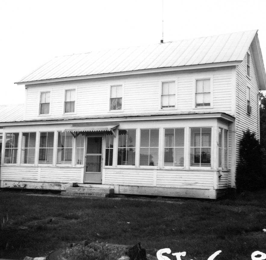
| Address | 179 Boston Rd |
| MACRIS ID | BIL.130 |
| Built | 1825 |
| Demolished | 1970 |
| Owners | Joseph Stearns (1823 - 1883) |
| Tenants | |
| Fairway Farm Dairy (1950 - 1958) | |
The Joseph Stearns House stood at 179 Boston Road, in the corner where Treble Cove Road leaves Boston Road (Route 3A) in North Billerica, at the north tip of the land now occupied by Treble Cove Plaza. The site is a wedge of land between the old "Mock meadow road" (Treble Cove Road) and "the old road" (Boston Road).
The land was part of the farm by the fordway that Christopher Osgood sold in 1742 to Nicholas Sprake Jr., clothier, and that passed by his will (proved 1768) to his son Samuel Sprake. Samuel deeded undivided halves of his land to his sons Isaac Sprague (1782) and Levi (1784), and at the 1785 division of his estate Isaac took the westerly end of "the piece before the house", the land south of the Sprake house toward Major Farmer's. When Isaac Sprake's own estate was divided in 1811, his son Isaac received the "18 a. tillage" lot southwest of the Mock meadow road, by the heirs of Edward Farmer. No deed names the lot before 1811, so its descent from the Osgood purchase is probable rather than proved.
Isaac Sprake sold the 18 acres in 1817 to Nathan Mears and Nathaniel Stearns, bricklayer, for $306, and in January 1823 they sold it for $300 to Nathaniel's cousins Royal Stearns, bricklayer, and Joseph Stearns Jr., laborer; the deed names no buildings. When Royal died in 1825 his half was advertised with a "Dwelling house and barn thereon standing, both nearly new," so the brothers built the house between 1823 and 1825. Joseph Stearns bought Royal's half at auction on November 28, 1825 for $400, and Royal's widow Esther released her dower to him. He added a notch by the Mock meadow causeway in 1833 and two acres of Mock meadow from his cousin Nathaniel's estate in 1846, and lived on the place the rest of his life; Hazen wrote in 1883 that he "now lives on the Lowell road; no children."
After his death his executor, Dudley Foster, sold "The Homestead of the late said Joseph Stearns," 26 acres "with a dwelling house barn & other buildings thereon," at auction to Daniel Callahan in October 1883 for $3,600, taking back a $1,500 mortgage that was paid off in 1886. Callahan farmed there and added neighboring land until the place was some eighty acres, "known as the Daniel Callahan Homestead." He died on April 6, 1900, aged 65, and left it by will to his widow Ann and seven devisees, all named in a 1915 deed as his children: Josephine A. Greany, Mary A. Callahan, Annie Dwire, Daniel, Charles E. Callahan, Sabina G. Twombly and Elizabeth Ellen Callahan, a minor. In 1914 and 1915 two of the daughters released their shares to their brother Daniel and a third sold hers to Charles, and in November 1915 the heirs sold the town a lot of about three acres at the south end of the farm "for additional water supply."
The heirs registered the farm in the Land Court in 1926. The plan of that year (Land Court Plan 11471-A) draws the house and barn at the north tip, between Treble Cove Road and the State Highway. The day the decree was registered they sold the farm to Warren A. and Bertha S. Pike, who gave them back a $13,500 mortgage; in 1933 Middlesex County took land along the west side to relocate Treble Cove Road, and in 1934 the farm came back to Daniel E. Callahan "of Brown's Corner." He sold it in 1939 to Francois and Alphena Levesque of Dracut, and in 1950 it went to Gerard J. Levesque. In 1956 the land to the south was sold to Stop & Shop for the plaza (Lot 4 of Plan 11471-B), and the house, barn and corner were kept as Lot 6. The Historical Commission's survey form of January 1974 lists the house as demolished, stamped "Demolished 1970."
In 1982 Lot 6 was divided, and in 1983 the corner itself, Lot 13, passed to another member of the family, with a narrow strip (Lot 16) added in 1985. Kinder-Care Learning Centers, Inc. bought both lots in March 1990 and built the day-care center that stands there now (see 179 Boston Rd); the state took land along the front to widen Boston Road and Route 3A in 1990 and again in 2007. The lot passed within the KinderCare group to KC Propco, LLC in 2005 and to KCP RE LLC in 2015.
References
- MACRIS BIL.130
- Billerica assessor, 179 Boston Rd (parcel 22-10-1-2): day care built 1990 on 0.68 acre, Lots 13 and 16 of Land Court Plan 11471, sales history from 1983
Title References
| Date | Type | Grantor | Grantee | Summary | Recorded |
|---|---|---|---|---|---|
| 1718 | Deed | John Wallis of Billerica; Mary Wallis his wife releasing dower | Joseph Wyman of Billerica | 1718: John Wallis to Joseph Wyman, incl. 13 1/2 acres he bought of Samuel Danforth, bounded by the highways (probably this wedge) | 19/402 (South) |
For 90 pounds, "one messuage or house lot of land" of 38 acres on the west side of Concord River, bounded north by Capt. Samuel Hill, west by Thomas Ross, south by Capt. John Stearns and partly by the road to Chelmsford, east by the way to Osgood's mill and partly by Samuel Danforth; also 13 1/2 acres "which I purchased of Samuel Danforth", "together with all the buildings, fences and trees thereon". Dated May 2, 1718, acknowledged May 9 before Oliver Whiting. Billerica town book 2, pages 184-186. The earliest record of the lot; Wallis's own title is not recorded.
Title passed to:
|
|||||
| 1729 | Deed | Joseph Wyman of Billerica; Ruth Wyman his wife releasing dower | John Blanchard of Billerica | 1729: Joseph Wyman to John Blanchard, the same house lot and 13 1/2 acres | 35/409 (South) |
For 200 pounds, the same "messuage or house lot" of 38 acres (north on Capt. Samuel Hill, west Thomas Ross, south John Stearns and the road to Chelmsford, east the highway to Osgood's mill and Samuel Danforth) and the 13 1/2 acres bought of Samuel Danforth, "together with all the buildings, boards, fences and trees". Dated Feb. 1, 1728/9; recorded at Cambridge 1734. Billerica town book 3, pages 476-478. The tract was still called "the Wyman lot" in 1769.
Title from:
Title passed to:
|
|||||
| 1734 | Deed | John Blanchard of Billerica; Mary Blanchard his wife releasing dower | Christopher Osgood Jr. of Billerica | 1734: John Blanchard to Christopher Osgood Jr., the same | 36/617 (South) |
For 170 pounds, "one messuage or house lot of land" of about 38 acres on the west side of Concord River (north Capt. Samuel Hill, west Thomas Ross, south Capt. John Stearns and the road to Chelmsford, east the highway to Capt. Osgood's mill and Samuel Danforth) and 13 1/2 acres "purchased of Samuel Danforth", "together with all the buildings, fences and trees thereon". Dated Nov. 4, 1734. Billerica town book 4, pages 1-2.
Title from:
Title passed to:
|
|||||
| 1742 | Deed | Christopher Osgood of Billerica; Sarah Osgood his wife releasing dower | Nicholas Sprake Jr. of Billerica, clothier | 1742: Christopher Osgood to Nicholas Sprake Jr., the fordway farm south of the Sprake house (probable source of the lot) | 46/244 (South) |
For 750 pounds (old tenor), several tracts near Osgood's mills on the west side of Concord River, among them "the next tract of land is situate near the fordway over Concord River that leads from Chelmsford to Billerica Town on the west side of said river, sixty nine acres be it more or less with a house and barn thereon standing", bounded north by Deacon Samuel Hill, west by William Crosby, Samuel Barron and heirs of Capt. John Stearns, "south by Chelmsford road leading to the fordway and east by the highway leading to said Osgood's mill". Dated May 19, 1742; recorded 1745. Billerica town book 4, pages 540-542. Osgood had enlarged the Blanchard house lot with land of Samuel Danforth and Andrew Farmer.
Title from:
Title passed to:
Related:
|
|||||
| 1768 | Will | Estate of Nicholas Sprake of Billerica, clothier | His sons Nicholas, Samuel and John Sprake and daughters | 1768: will of Nicholas Sprake, the Osgood lot and Mock meadow land to son Samuel | Probate #21112 |
Will dated Sept. 15, 1761, proved 1768 (he died March 31, 1768). To son Nicholas the homestead by Broad Meadow; "to my well beloved son Samuel Sprake ... one lot of land with the buildings thereon which I bought of Christopher Osgood as it may appear bounded by a deed I put upon record of the same", with part of a lot bought of Samuel Hill, the Mock meadow land bought of widow Rebecca Farmer and 2 acres of meadow bought of John Dunkin, "all which joins upon the house lot"; to son John 40 acres in Tewksbury with a grist mill. Sons Nicholas and Samuel executors.
Title from:
Title passed to:
|
|||||
| October 11, 1785 | Quitclaim | Nicholas Sprake Jr. and John Sprake of Billerica, husbandmen | Their brother Samuel Sprake of Billerica, husbandman | 1769: Nicholas Jr. and John Sprake quitclaim the homestead and the land to Mock meadow to Samuel | 89/382 (South) |
For 133 pounds 6s 8d, quitclaim of their rights in lots "which belonged to our honoured father Mr. Nicholas Sprake": "The Wyman lot so called, beginning at the road by the Fordway at a stake and stones by the end of a stone wall at the corner of the Hills lot so called, thence running westerly ... to the road leading to Seth Leviston's ... thence bounded westerly and southerly by the said road to the Fordway ... with all the buildings thereon standing and being"; a 9-acre lot toward James Laws; and upland and meadow at Duncan meadow and Mock meadow to Concord River. Dated July 3, 1769, acknowledged before William Stickney; recorded Oct. 11, 1785. Billerica town book 7, pages 499-501.
Title from:
Title passed to:
|
|||||
| October 11, 1785 | Deed | Samuel Sprake of Billerica, yeoman | His son Isaac Sprague of Billerica | 1782: Samuel Sprake gives son Isaac an undivided half of his land | 89/384 (South) |
For 100 pounds, "one undivided half part of all my lands and buildings" in Billerica, 70 or 80 acres in the whole, Isaac not to come into possession "until the death of his father". Dated July 22, 1782; proved at the Sessions in September 1785, Samuel being "now deceased"; recorded Oct. 11, 1785. Billerica town book 7, pages 502-503.
Title from:
Title passed to:
|
|||||
| October 11, 1785 | Deed | Samuel Sprake of Billerica, yeoman | His son Levi Sprake of Billerica | 1784: Samuel Sprake gives son Levi the other half | 89/381 (South) |
For 100 pounds, the other "undivided half part of all my lands and buildings" in Billerica, 70 or 80 acres, Levi not to take possession until his father's death. Dated April 10, 1784; proved September 1785 after Samuel's death; recorded Oct. 11, 1785. Billerica town book 7, pages 497-499. Shows Samuel alive in April 1784, against Hazen's death date of 1781.
Title from:
|
|||||
| 1785 | Administration and Division | Estate of Samuel Sprake of Billerica, yeoman | His sons Isaac and Levi Sprake; widow Ruth Sprake (dower) | 1785: Samuel Sprake estate divided; Isaac takes the westerly end of the piece south of the house | Probate #21116 |
Administration to son Isaac, June 8, 1785. Inventory: "the dwelling house" 25 pounds, "the barn" 15, home lot of about 30 acres bounded north by heirs of Nicholas Sprake and elsewhere by the highway, 40 acres south of the house to Concord River, a hill pasture. The commissioners set off widow Ruth's dower (the westerly part of the house, lower room and room above, lean-to) and severed Samuel's half from Isaac's: to Isaac "the east end of the dwelling house, that is to say the lower room and the garrets and the east part of the cellar", half the barn and 6 1/2 acres at the east end of the homestead; to Levi (a minor) "the westerly end of the dwelling house and the east chamber" and the westerly 18 acres. Accepted Nov. 20, 1785.
Title from:
Title passed to:
Related:
|
|||||
| 1799 | Will, Inventory and Division | Estate of Isaac Sprague of Billerica, yeoman | Widow Rhoda (later Hodgman); children Polly Dows, Rhoda and Isaac Sprake | 1811: division of Isaac Sprake's estate; the 18-acre tillage lot to son Isaac | Probate #21107 |
Will dated Feb. 7, 1799, proved April 10, 1799: to wife Rhoda "the improvement of all my real estate so long as she shall remain my widow", one third if she remarried; remainder to Polly, Rhoda and Isaac. Inventory: "the homestead ... on the west side of Concord River near the Fordway (so called) containing sixty acres of good land with the buildings thereon" $1250. Division of Dec. 23, 1811: to Rhoda, "late widow, now wife of Abijah Hodgman", "the east room on the lower floor and the chamber over it to the middle of the chimney", the east part of the barn and 15 acres south of the house; to son Isaac "the westerly part of the house to the middle of the chimney together with the garret over the east room", the west part of the barn and the house lot of 6 acres 138 rods; other land to Polly Dows and Rhoda.
Title from:
Title passed to:
Related:
|
|||||
| May 21, 1817 | Deed | Isaac Sprake of Billerica, yeoman | Nathan Mears, yeoman, and Nathaniel Stearns, bricklayer | 1817: Isaac Sprake to Nathan Mears and Nathaniel Stearns, 18 acres by the Mock meadow road | 222/41 (South) |
For $306, 18 acres of woodland and mowing by the Mock-meadow road and the old road, by land formerly of Levi Sprake and Henry Newman (the 18-acre tillage lot of the 1811 division). Dated April 15, 1817. Billerica town book 12, page 20. Farm land only, not the house.
Title from:
Title passed to:
|
|||||
| April 30, 1823 | Deed | Nathan Mears of Billerica, innholder, and Nathaniel Stearns of Billerica, bricklayer; Lucy Mears and Sarah Stearns releasing dower | Royal Stearns of Billerica, bricklayer, and Joseph Stearns Jr. of Billerica, laborer | 1823: Mears and Stearns to Royal and Joseph Stearns Jr., 18 acres, $300 | 247/524 (South) |
For $300, "a certain tract of land situated in said Billerica west of Concord River containing eighteen acres more or less", beginning "at the northeasterly corner at the end of a Ditch by Mock Meadow Cause way so called", northerly by "Mock meadow Road" 102 rods "to the old road", southwesterly by the old road to land formerly of Levi Sprake, then by Levi's land and land formerly of Henry Newman to the corner first mentioned, "being the same conveyed to us by Isaac Sprake by his deed bearing date the 15th day of April 1817." No buildings are named. Signed January 28, 1823. Billerica town book 13, pages 207-208.
Title from:
Title passed to:
|
|||||
| 1825 | Administration | Estate of Royal Stearns of Billerica, bricklayer | David Reed Jr. of Bedford, administrator; widow Esther Stearns; one minor child | 1825: Royal Stearns estate; house and barn "both nearly new" | Probate #21322 |
Royal Stearns died intestate in 1825, leaving "a widow & one child only who is a minor"; his widow Esther declined and David Reed Jr. of Bedford, cooper, was appointed administrator September 6, 1825. Debts of $190.67 (among them $36 to Joseph Stearns Jr.) against personal estate of $133.71 and real estate of $400. Under a license of the Supreme Judicial Court the administrator advertised "one undivided half of about eighteen acres of land, Dwelling house and barn thereon standing, both nearly new, situated in Billerica west of Concord River, on the great stage road & within one hundred rods of the Canal Mills", and on November 28, 1825 sold it at auction "to Joseph Stearns Junr. for the sum of Four Hundred Dollars."
Related:
|
|||||
| March 7, 1827 | Administrator's Deed | David Reed Jr. of Bedford, yeoman, administrator of the estate of Royal Stearns of Billerica, bricklayer | Joseph Stearns Jr. of Billerica, yeoman | 1825: Royal Stearns's half sold at auction to Joseph Stearns Jr., $400 | 272/413 (South) |
Under a license of the Supreme Judicial Court at Cambridge (October term, 1825), sold at public vendue on the premises on November 28, 1825 for $400, "he being the highest bidder", "one undivided half of a certain tract of land situated in said Billerica west of Concord River, with one undivided half of the buildings standing thereon, containing eighteen acres", from the end of a ditch by "Mock Meadow cause way", northerly by the road to land of Josiah B. French (around a notch of French's land 8 by 10 rods), "northerly by said road till you come to an old road leading to Benjamin Frost's", southerly by the old road to land formerly of Levi Sprake and by Henry Newman's land to the beginning. Signed November 28, 1825. Billerica town book 13, pages 453-455.
Title from:
Title passed to:
Related:
|
|||||
| March 7, 1827 | Release of Dower | Esther Stearns of Billerica, widow | Joseph Stearns Jr. of Billerica, yeoman | 1825: widow Esther Stearns releases her dower to Joseph Stearns Jr. | 272/415 (South) |
For $100, quitclaim of "all my right title & interest & rights of dower in & to a certain tract of land with the buildings thereon situated in said Billerica west of Concord River containing eighteen acres", with the same bounds as the administrator's deed of the same day. Signed November 28, 1825, witnessed by David Reed Jr. and Marshall Preston. Billerica town book 13, pages 455-456.
Related:
|
|||||
| November 12, 1833 | Quitclaim | Josiah B. French of Billerica; Mary Ann French his wife releasing dower | Joseph Stearns Jr. of Billerica | 1833: Josiah B. French notch by Mock Meadow causeway to Joseph Stearns Jr. | 327/301 (South) |
Quitclaim of "a certain piece of land situate in said Billerica containing eighty poles", beginning "at Mock meadow causeway by a ditch", westerly 8 rods on the ditch, northerly 10 rods, easterly 8 rods, southerly 10 rods by the causeway; "said land is bounded on all sides by land of said Stearns except the said causeway." Signed May 21, 1833. Billerica town book 16, page 296. This is the French notch named in the 1825 bounds.
Title passed to:
|
|||||
| 1846 | Executor's Deed | Marshall Preston of Billerica, executor of the will of Nathaniel Stearns of Billerica | Joseph Stearns of Billerica, yeoman | 1846: 2 acres 3 rods of Mock meadow to Joseph Stearns | 486/340 (South) |
Under the power of sale in the will, for $30, "the following tract of meadow land situate in said Billerica in Mock meadow so called containing two acres and three rods more or less", bounded easterly and northerly by land of Joseph Stearns, southerly by William Pollard and westerly by the deceased's land, "being the same conveyed to said deceased by Amasa Holden by deed dated October 2nd 1845". Billerica town book 18, pages 167-168. Probably part of the 26 acres of 1883.
Title passed to:
|
|||||
| October 31, 1883 | Executor's Deed | Dudley Foster of Billerica, executor of the will of Joseph Stearns of Billerica | Daniel Calaghan (Callahan) of Billerica | 1883: Joseph Stearns homestead, 26 acres, to Daniel Callahan, $3,600 | 163/345 |
Under a Probate Court license of September 11, 1883, sold at public auction on October 8 to Daniel Calaghan, the highest bidder, for $3,600: "The Homestead of the late said Joseph Stearns situate in said Billerica containing twenty six acres more or less with a dwelling house barn & other buildings thereon", beginning at the southeasterly corner at land of Dudley Foster by "Mock Meadow causeway so called", northerly by Mock Meadow road to the old road (indexed as the old road "to Shore's Place"), southwesterly by the old road to land of Coburn S. Smith, then by Smith, John Daly (reading uncertain) and Foster to the beginning; also a 6-acre lot on "the Great road leading from Billerica to Lowell" by the Hutchins place and Foster. Signed October 30, 1883.
Title from:
Title passed to:
|
|||||
| October 31, 1883 | Mortgage | Daniel Calaghan (Callahan) of Billerica | Dudley Foster of Billerica | 1883: Daniel Callahan mortgage back to the executor, $1,500, discharged 1886 | 163/352 |
For "fifteen hundred dollars" paid by Dudley Foster, mortgage of "the Homestead of the late Joseph Stearns situate in said Billerica containing twenty six acres more or less with a dwelling house barn & other buildings thereon", from the southeasterly corner at land of Dudley Foster by "Mock meadow causeway so called", northerly by Mock meadow road "to the old road leading to the Shores place", southwesterly by the old road to land of Coburn S. Smith, then by Smith, John Daly (reading uncertain) and Foster; also the 6-acre lot on "the Great road leading from Billerica to Lowell" at Jacob K. Hutchins's land; "Being the same premises conveyed to me by Dudley Foster executor of the will of the late Joseph Stearns". Given back on the day of the sale to secure part of the $3,600 price; recorded October 31, 1883. Margin: "Lowell April 1, 1886. Having received full payment and satisfaction for this mortgage I hereby cancel and discharge the same. Dudley Foster."
Related:
|
|||||
| November 15, 1915 | Quitclaim | Josephine A. Greany of Wakefield (Dennis Greany her husband releasing) and Mary A. Callahan of Billerica, unmarried | Their brother Daniel Callahan (Daniel E. Callahan) of Billerica | 1914: Greany and Mary A. Callahan release the "Daniel Callahan Homestead" to their brother Daniel | 547/106 |
For one dollar, their right in "a certain tract of land situated at North Billerica, so called, in said Billerica, on the Boston road, comprising about eighty acres, and bounded by land of one Coburn Smith, and land of one Burton O. Sanford. Said premises are known as the Daniel Callahan Homestead. We derive our title and interest in said real estate as devisees of our father, Daniel Callahan, late of said Billerica, deceased, and our mother, Ann Callahan late of said Billerica, deceased"; also about eight acres adjoining land of one Colson on the Boston road, and any other Billerica land. Dated April 30, 1914; recorded November 15, 1915 with the other heirs' deeds. Daniel Callahan the father died April 6, 1900, aged 65 (town report); his will was proved in the Middlesex Probate Court (after 1871, outside the online index).
Title from:
Title passed to:
|
|||||
| November 15, 1915 | Quitclaim | Annie Dwire of Lowell (Timothy J. Dwire her husband releasing) | Her brother Charles E. Callahan of Billerica | 1915: Annie Dwire releases her seventh to Charles E. Callahan | 547/108 |
For consideration paid, "an undivided one seventh and whatever further interest I may have" in three parcels "with the buildings thereon": first, the premises in the deed "from Dudley Foster, executor of the will of Joseph Stearns to Daniel Callahan, father of the grantor and grantee", Book 163, Page 345; second, the land bought of Sarah M. Webster, administratrix of Prentiss Webster, September 18, 1899 (Book 313, Page 224); third, a collector's tax deed from Calvin P. Sawyer, September 16, 1892 (Book 237, Page 73). "The grantor derives her title as devisee under the will of her father, the said Daniel Callahan, late of said Billerica, deceased, whose will was duly probated and allowed in the Probate Court for said County of Middlesex." Dated September 21, 1915; recorded November 15, 1915.
Title from:
|
|||||
| November 15, 1915 | Quitclaim | Daniel Callahan and Charles E. Callahan, both unmarried, and Sabina G. Twombly (Edgar F. Twombly her husband releasing), all of Billerica | Inhabitants of Billerica | 1915: Callahan heirs sell the town a water-supply lot from the south end of the farm | 547/109 |
For one dollar, "an undivided six-sevenths" of about 3.24 acres on "the westerly side of Causeway road", bounded by John H. Foster 514.7 feet, "other land of the heirs of Daniel Callahan", Burton O. Sanford 250.2 feet and the road 102.4 feet, shown on the "Plan of land of heirs of Daniel Callahan, to be purchased for additional water supply, Billerica, Mass., August 12, 1915" (Plan Book 33, Plan 5). "Being a part of the same premises conveyed to Daniel Calaghan father of the grantors, late of said Billerica, deceased testate ... by Dudley Foster, executor of the will of Joseph Stearns ... book 163, page 345, and being a part of the same premises devised by said Daniel Calaghan to his children, Josephine A. Greany, Mary A. Callahan, Annie Dewire, Elizabeth E. Callahan, the said Daniel Callahan, the said Charles E. Callahan, and the said Sabina G. Twombly"; recites the Greany and Dwire deeds. Dated November 11, 1915; recorded November 15, 1915. The town water-supply land at the south end of the farm, later the "Inhabitants of Billerica" parcel on Land Court Plan 11471-A.
Title from:
Related:
|
|||||
| November 15, 1915 | Guardian's Deed | Charles E. Callahan of Billerica, guardian of Elizabeth Ellen Callahan, "minor and child of Eliza Moloney late of Lowell" | Inhabitants of Billerica | 1915: guardian of Elizabeth E. Callahan sells her seventh of the water-supply lot | 547/111 |
Under a license of the Middlesex Probate Court of October 28, 1915, sold at private sale to the town for $85.72 "one undivided seventh" of the same 3.24-acre water-supply lot (Plan Book 33, Plan 5), the ward's share as one of the seven devisees of Daniel Callahan. Recorded November 15, 1915. With Book 547, Page 109 it gave the town the whole lot.
Related:
|
|||||
| June 30, 1926 | Land Court Decree | Land Court decree, case 11471 (petition of Daniel E. Callahan et al.) | Daniel E. Callahan, Sabina G. Twombly and Elizabeth E. Callahan of Billerica | 1926: Land Court decree for the Callahan heirs (Lot 1 of Plan 11471-A) | Ctf 3113 |
Original Certificate of Title 3113 on the decree of June 29, 1926: the three, "all unmarried", own the land in undivided sevenths (Elizabeth one seventh, the others two sevenths each; reading partly uncertain). Lot 1: "Westerly by Treble Cove Road about eleven hundred one (1101) feet", "Northeasterly by the southwesterly line of the State Highway two thousand thirty-four and 91/100 (2034.91) feet", then by the Inhabitants of Billerica, Felix Letendre, Frank D. Foster, Burton O. Sanford and Joseph H. Sylvester Jr. to Bridge Street, back up Treble Cove Road 1,353 feet and around "Mabelle M. Smith et al." Lot 2 lies east of the highway and Lot 3 on Concord River, on the J. C. and W. T. Monahan plan of February 6, 1926 (Land Court Plan 11471-A). Subject to a lease to Edward P. Collins of April 1, 1925.
Title from:
Title passed to:
Related:
|
|||||
| June 30, 1926 | Certificate of Title | Daniel E. Callahan, Sabina G. Twombly and Elizabeth E. Callahan | Warren A. Pike and Bertha S. Pike of Billerica, joint tenants | 1926: to Warren A. and Bertha S. Pike | Ctf 3114 |
Transfer Certificate from Original Certificate 3113, entered the day after the decree: the Pikes own Lots 1, 2 and 3 of Plan 11471-A, the same bounds.
Title from:
Title passed to:
|
|||||
| June 30, 1926 | Mortgage | Warren A. Pike and Bertha S. Pike | Daniel E. Callahan et al. | 1926: Pikes mortgage the farm back to the Callahan heirs, $13,500 | Ctf 3114 |
Registered document 6933, noted on the memoranda of Certificates 3114 and 4670: a $13,500 mortgage for ten years at 6%, with the statutory condition and power of sale, dated and registered June 30, 1926, the day the Pikes took title; the purchase money owed to the Callahan heirs. Discharged by document 11249, filed February 1935, after the land had come back to Daniel E. Callahan (Certificate 4670, 1934).
Related:
|
|||||
| April 15, 1933 | Taking | Warren A. Pike and Bertha S. Pike (registered owners) | Middlesex County, for highway purposes | 1933: Middlesex County taking for the relocation of Treble Cove Road | Ctf 3114 |
Registered document 10235, noted on the memoranda of Certificate 4670: a taking by Middlesex County "For Highway purposes", terms "Relocation of Treble Cove Rd.", dated April 7, 1933 and registered April 15, 1933. It moved the line of Treble Cove Road along the west side of the old Stearns homestead; a second county relocation followed in 1959 (Certificate 8097).
Related:
|
|||||
| October 22, 1934 | Certificate of Title | Warren A. Pike and Bertha S. Pike | Daniel E. Callahan of Billerica, not married | 1934: back to Daniel E. Callahan | Ctf 4670 |
Transfer Certificate from Certificate 3114: Daniel E. Callahan of "Brown's Corner, Billerica" owns Lots 1, 2 and 3 again, the same bounds, subject to the Middlesex County taking of April 7, 1933 for the "Relocation of Treble Cove Rd." The face does not name the instrument behind the transfer.
Title from:
Title passed to:
Related:
|
|||||
| 1939 | Certificate of Title | Daniel E. Callahan | Francois Levesque and Alphena Levesque of Dracut, tenants by the entirety | 1939: to Francois and Alphena Levesque | Ctf 5365 |
Transfer Certificate from Certificate 4670, registered in February 1939 (the day is not legible on the next certificate): Lots 1, 2 and 3 of Plan 11471-A, the same bounds. Memoranda: a grant of rights to the Lowell Electric Light Corp. (1936) and a $1,700 mortgage to the Federal Land Bank of Springfield (February 24, 1939).
Title from:
Title passed to:
|
|||||
| March 20, 1950 | Certificate of Title | Francois Levesque and Alphena Levesque | Gerard J. Levesque of Billerica, married to Margaret Levesque | 1950: to Gerard J. Levesque; subdivided in 1956 | Ctf 8097 |
Transfer Certificate from Certificate 5365 (deed document 20955): Lots 1, 2 and 3 of Plan 11471-A. Memoranda: a $4,200 Federal Land Bank mortgage (1950); Lot 2 sold in 1954; "Lot 4 on subdivision plan" to Stop & Shop Inc., Boston, September 14, 1956; a second Middlesex County taking for the relocation of Treble Cove Road (June 9, 1959); later lots sold off into the 1980s and 1990s.
Title from:
Title passed to:
|
|||||
| September 14, 1956 | Certificate of Title | Gerard J. Levesque (deed document 28099) | Stop & Shop, Inc., Boston | 1956: plaza lot (Lot 4) sold; the house lot (Lot 6) kept | Ctf 10025 |
Transfer Certificate from Certificate 8097: "Westerly by Treble Cove Road, six hundred twenty-three and 35/100 (623.35) feet; Northerly by Lot 6, four hundred thirty-four and 99/100 (434.99) feet; Northeasterly by State Highway, nine hundred ninety-six and 18/100 (996.18) feet; Southeasterly by Lot 5, three hundred seventy-three and 85/100 (373.85) feet", southwesterly by Mabelle M. Smith et al. 647.18 feet, "shown as Lot four (4)" on the subdivision plan by Dana F. Perkins and Sons, Inc. of February 23, 1956 (Land Court Plan 11471-B; the copy is at Registration Book 53, Page 49). The plaza lot.
Title from:
Title passed to:
|
|||||
| April 26, 1983 | Certificate of Title | Gerard J. Levesque (Lot 6 of Plan 11471-B, from Certificate 8097) | A private owner (a member of the Levesque family) | 1983: Lot 13 (the house corner, cut from Lot 6) to a private owner | Ctf 25157 |
Partial Transfer Certificate from Certificate 8097, registered April 26, 1983: Lot 13 of Land Court Plan 11471-F (Fleming Bienvenu & Associates, August 31, 1982), "Northwesterly by Treble Cove Road, one hundred eighty-four and 92/100 (184.92) feet; Northerly by a curved line forming the junction of said Treble Cove Road and State Highway, thirty-seven and 45/100 (37.45) feet; Northeasterly by said State Highway, one hundred fifty-two (152) feet", southeasterly 114.56 feet and southwesterly 145.16 feet by Lot 14. Plan 11471-F is the "Subdivision of Lot 6 Shown on Plan 11471-B" into Lots 13 and 14: Lot 13 is the corner where the Stearns house stood. Owner's address "179 Boston Rd." Memoranda: Conservation Commission order of conditions (1981, extended 1983), a 1986 bank mortgage (discharged 1987), the KinderCare special permit of January 9, 1990, and a change-of-name certificate for Kinder-Care. Cancelled by deed document 130886 (March 29, 1990), Certificate 29233.
Title from:
Title passed to:
Related:
|
|||||
| March 29, 1990 | Certificate of Title | A private owner (a member of the Levesque family) | Kinder-Care Learning Centers, Inc., a Delaware corporation of Montgomery, Alabama | 1990: Lots 13 and 16 to Kinder-Care Learning Centers, Inc. | Ctf 29233 |
Transfer Certificate from Certificates 25157 and 26361 (Registration Books 128 and 134, Pages 313 and 321; originally registered April 26, 1983 and March 13, 1985), on deed document 130886 (the assessor records the sale on March 29, 1990 for $330,000): Lot 13 of Plan 11471-F (the corner lot, as in Certificate 25157) and Lot 16 of Plan 11471-H (Fleming, Bienvenu & Associates, November 23, 1983), "Northwesterly by Treble Cove Road, twenty-one and 68/100 (21.68) feet; Northeasterly by Lot 13, one hundred forty-six and 34/100 (146.34) feet", southeasterly 85.44 feet and southwesterly 109.13 feet by Lot 15, a strip added to the corner lot in 1985. The day-care center was built in 1990. Cancelled: "See deed - document 235583, see certificate no. 38249, registration book 194 page 99."
Title from:
Title passed to:
|
|||||
| October 18, 1990 | Order of Taking | Kinder-Care Learning Centers, Inc. (registered owner) | Massachusetts Department of Public Works | 1990: state taking to widen Boston Road and Route 3A | Ctf 29233 |
Registered document 133278, noted on the memoranda of Certificates 29233, 38249 and 42454: an order of taking by the Massachusetts Commissioners of Public Works dated September 26, 1990 and registered October 18, 1990, "To alter Boston Rd & Rt 3A", the widening of the State Highway along the northeast side of Lots 13 and 16. The assessor's card notes "LAND TAKING".
Related:
|
|||||
| December 2, 2005 | Certificate of Title | Kinder-Care Learning Centers, Inc. | KC Propco, LLC, a Delaware limited liability company of Portland, Oregon | 2005: to KC Propco, LLC | Ctf 38249 |
Transfer Certificate from Certificate 29233 on deed document 235583, registered December 2, 2005 (assessor: $100, a transfer within the KinderCare group): Lot 13 of Plan 11471-F and Lot 16 of Plan 11471-H. Registered the same day: a $650,000,000 mortgage to Mortgage Electronic Registration Systems, "Other land included" (document 235585), the financing of the KinderCare centers nationwide.
Title from:
Title passed to:
|
|||||
| August 30, 2007 | Order of Taking | KC Propco, LLC (registered owner) | Massachusetts Highway Department | 2007: state highway taking | Ctf 38249 |
Registered document 245258, noted on the memoranda of Certificate 42454: an order of taking by the Massachusetts Highway Department dated August 22, 2007 and registered August 30, 2007, "To alter state highway" (Boston Road, Route 3A, at Treble Cove Road).
Related:
|
|||||
| August 19, 2015 | Certificate of Title | KC Propco, LLC | KCP RE LLC, a Delaware limited liability company of Coconut Grove, Florida | 2015: to KCP RE LLC (owner to date) | Ctf 42454 |
Transfer Certificate from Certificate 38249 (originally registered December 2, 2005), August 19, 2015 (assessor: $1): Lot 13 of Plan 11471-F and Lot 16 of Plan 11471-H, the KinderCare center at 179 Boston Road, 0.68 acre (assessor parcel 22-10-1-2, which "COMBINES 10-1-1 + 10-2-1 LC PLAN 11471H, LOTS 13+16"). The registered owner to date; later memoranda are portfolio mortgages of 2015 ($550,000,000) and 2021 ($641,800,000) and certificates of good standing.
Title from:
|
|||||
Recorded is Book/Page at the Middlesex North Registry of Deeds unless noted; Probate # is a Middlesex probate case, Ctf a Land Court certificate of title.