Structure · Built 1910
George F. Colson Two-Family House
George F. Colson Two-Family House
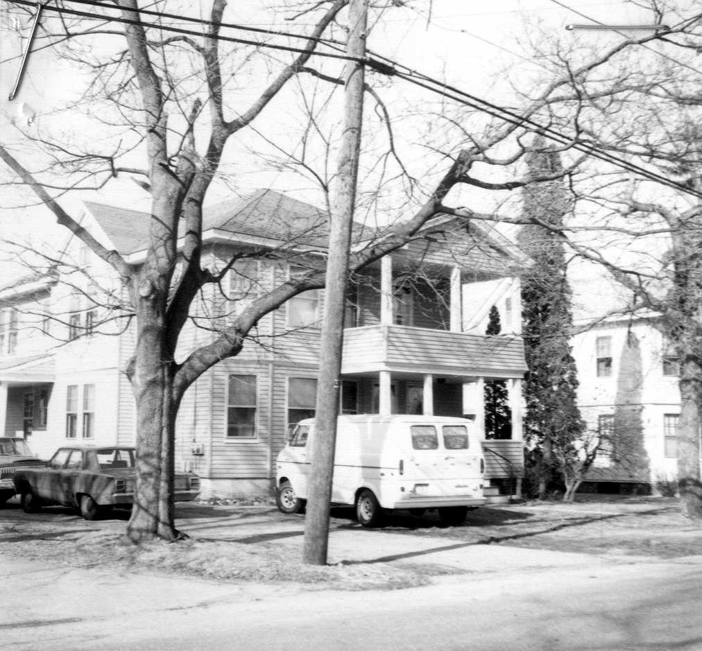
| Address | 18-20 Colson St |
| MACRIS ID | BIL.257 |
| Built | 1910 |
The two-family house at 18-20 Colson Street, on the corner of Kohlrausch Avenue in North Billerica, stands on land that was part of the old Sprake, Farmer and Colson homestead farm. Nicholas Sprake bought the farm "with a Dwelling house and Barn" in 1724; Oliver Farmer Jr. acquired it from the Sprake estate in 1787 and 1790 and left it by his will in 1839 to his son-in-law Israel A. Colson, who deeded "my Homestead Farm" to his son George F. Colson in 1884.
After George F. Colson died, his administrator Edgar F. Twombly and his heirs conveyed the farm in 1914 to Charles H. McIntire of Lowell as trustee, and the land was laid out as the house lots of Colson Heights (Plan Book 31, Plan 88). This house occupies lots A and C of section 18: Lot C on the west side of Colson Street and Lot A behind it on the south side of what was then "a proposed street called Kohlrausch avenue," together an L-shaped lot of about 12,863 square feet.
On November 13, 1914 McIntire, as trustee, sold the two lots to Elmer E. Perrigo of Billerica, and the deed already described them as "two certain lots of land with the buildings thereon." The house was therefore standing before the trustee's first sale, which agrees with the assessor's date of about 1910 and means it was built while the land was still part of the Colson farm. Perrigo passed the property in October 1915 to Sarah J. Ellis, subject to two mortgages, and on July 9, 1920 she and her husband Thomas A. Ellis sold it to John T. MacLean and his wife Amanda M. MacLean as tenants by the entirety.
In 1921 the town petitioned the Middlesex County Commissioners to relocate Colson Street; the relocation was adjudged "of common convenience and necessity" in January 1922 and recorded in 1924, and later deeds of the lot are made subject to it. Amanda MacLean died on January 17, 1927, and her husband, by then of Concord, New Hampshire, sold the house on February 1, 1945 to Frederick Wain and Edith A. Wain, who already owned the land to the south.
The Wains sold "the land ... with the buildings thereon" in October 1952 to a couple from North Cambridge, who were still the owners when the house was surveyed in 1980, when it was described as a two-story, two-family Colonial Revival house with front and side porches. It has since passed between private owners, most recently in 2021.
References
Title References
| Date | Type | Grantor | Grantee | Summary | Recorded |
|---|---|---|---|---|---|
| July 14, 1726 | Deed | William Grimes of Billerica | William Chandler of Billerica | first-range lot, part of the later Sprake homestead | 26/96 (South) |
For 8 pounds, "one parcel of Land situate in Billerica aforesaid lying on the west of Concord River in the First Range of Lotts containing nineteen Acres and seventy four Poles," bounded northwest by "Chelmsford Line" about 12 1/2 poles, northeast by Thomas Dutton about 258 poles, southeast "by the Road to broad medow" about 18 poles and southwest by James Kidder about 268 poles, "and there is allowance made in the Lott for the highway upon it." No buildings are named. Dated Dec. 8, 1714; acknowledged Aug. 9, 1716 before Oliver Whiting; recorded July 14, 1726. Billerica town book 3, pages 33-35 (Southern Registry Book 26 Page 96). One of the long, narrow town division lots between the road to Broad Meadow (Colson Street) and the Chelmsford line that William Chandler put together into the 95-acre farm.
Title passed to:
|
|||||
| July 14, 1726 | Deed | Samuel Fassett of Billerica | William Chandler of Billerica | first-range lot, part of the later Sprake homestead | 26/97 (South) |
For 12 pounds, "one parcel of Land situate in Billerica ... containing forty acres and seventy four Pole ... lying on the west of Concord River in the first Range of Lotts," bounded west by Chelmsford line about 124 poles, southwest by Thomas Dutton about 165 poles, and east "by the Land of Isaac Stearns and the Proprietors of broad medow according to marked Trees"; "the northward Corner is a white oak Tree marked F," the westward a great rock, the eastward a white oak marked E.D.W., with allowance for the highway. No buildings are named. Dated Dec. 8, 1714; acknowledged Apr. 11, 1716 before Jonathan Tyng; recorded July 14, 1726. Billerica town book 3, pages 35-37 (Southern Registry Book 26 Page 97). The white oak "marked F" is the northwest corner of the farm Chandler sold to Nicholas Sprake in 1724.
Title passed to:
|
|||||
| June 15, 1726 | Deed | William Chandler of Billerica, with Susannah his wife releasing dower | Nicholas Sprake of Billerica | Chandler to Nicholas Sprake: the homestead farm this lot was cut from | 25/453 (South) |
For 300 pounds, "One Messuage or house Lott Scituate Lying and being in Billerica aforesaid Containing Ninety five acres more or less with a Dwelling house and Barn thereon standing," bounded "Northerly by Broad meadow in a crooked line Westerly by Chelmsford line Southerly by the Land of James Kidder Easterly by the said High Way to Broad meadow," the northwest corner "a White oak tree marked F"; also meadow in Long Hill meadow "which was Granted to Wm Hamlet," swamp bought of the committee for straightening the fence, and lots in the easterly part of Chelmsford and Chelmsford Neck. Dated Aug. 4, 1724 (witnesses Joseph Wyman, Mary Highgate); acknowledged Aug. 5, 1724 before Oliver Whiting; recorded June 15, 1726. Billerica town book 3, pages 18-21 (Southern Registry Book 25 Page 453). The first record of a house and barn on the farm: Chandler had bought bare division lots in 1714, so he built them between 1714 and 1724. The "High Way to Broad meadow" is Colson Street.
Title from:
Title passed to:
|
|||||
| 1768 | Will | Estate of Nicholas Sprake of Billerica, clothier | His sons Nicholas, Samuel and John Sprake and daughters | Nicholas Sprake will: homestead to his son Nicholas | Probate #21112 |
Will dated Sept. 15, 1761, proved 1768 (he died March 31, 1768). To son Nicholas the homestead by Broad Meadow; "to my well beloved son Samuel Sprake ... one lot of land with the buildings thereon which I bought of Christopher Osgood as it may appear bounded by a deed I put upon record of the same", with part of a lot bought of Samuel Hill, the Mock meadow land bought of widow Rebecca Farmer and 2 acres of meadow bought of John Dunkin, "all which joins upon the house lot"; to son John 40 acres in Tewksbury with a grist mill. Sons Nicholas and Samuel executors.
Title from:
Title passed to:
|
|||||
| October 2, 1784 | Quitclaim | John Sprake and Samuel Sprake of Billerica, husbandmen | Their brother Nicholas Sprake Jr. of Billerica, husbandman | Sprake brothers release | 85/549 (South) |
For 266 pounds 13 shillings 4 pence, a release of lots "which was part of our honoured Father Mr. Nicholas Sprake's Estate," the first beginning at the highway "by the ford way at the end of the stone wall by the Wyman lot so called," to the highway leading to Seth Levestone's, then east "to a stake and stones by the road leading to broad meadow standing about three feet southward of the bars which goes into the barn yard," "with one half of the west end of the dwelling house thereon both above and below and the one half of the east chamber and the East garret with conveniency of yard room about the house And also the one half of the barn and leanto adjoining"; also 15 acres west of the road to Levestone's, a lot in Broad Meadow by Concord River, and half of three acres in Mock Meadow from the brothers' division. Dated and acknowledged July 3, 1769 before William Stickney; recorded Oct. 2, 1784. Billerica town book 7, pages 417-419 (Southern Registry Book 85 Page 549).
Title from:
Title passed to:
|
|||||
| October 2, 1784 | Quitclaim | Samuel Sprake of Billerica, husbandman | His brother Nicholas Sprake Jr. of Billerica | Sprake brothers release | 85/551 (South) |
For 10 pounds, the easterly end of the land "set off by a committee to John Sprake late of Billerica Decd," from the highway leading to Broad Meadow by Nicholas's land to the New Meadow and Broad Meadow, by Nicholas's own land to Concord River, by the river to Mr. Carlton's land and by the wall on the west side of the highway, "together with the buildings and priviledges that was by said Comtee set off for or did in any wise belong unto the aforesaid John Sprake deceased and to our Honoured Mother the widow Judith Sprake and to our sister Elizabeth." Dated June 26, 1773; acknowledged Nov. 4, 1774 before William Stickney; recorded Oct. 2, 1784. Billerica town book 7, pages 420-421 (Southern Registry Book 85 Page 551). With the 1769 release it put the whole of the father's homestead in Nicholas Jr.
Title from:
Title passed to:
Related:
|
|||||
| 1784 | Administration and Dower | Estate of Nicholas Sprake (Jr.) of Billerica, yeoman, deceased intestate | His widow Margaret Sprake, administratrix (dower), and his heirs | Nicholas Sprake Jr. estate and dower | Probate #21114 |
Administration to the widow Margaret, Sept. 8, 1784. The appraisers found "about eighty acres, with the house and barn thereon standing," worth 200 pounds; the real estate inventory of Oct. 21, 1784 lists "one old Dwelling House Eight pounds," "one Barn prised at Eight pounds," "Seventy nine and a half acres called the Homsted" (by Samuel Sprake, Timothy Levingstone, Wm. Manning, Ebenr. French, the widow Carlton and Concord River) and 18 1/2 acres south of the road. The widow's dower was "The Middle Room in said deceased's House from bottom to top" with part of the cellar and the oven, about twenty acres of the homestead whose line ran "to the South Corner of the Barn yard then runs Southerly to the West end of the House then by the back of said House to the Road," five acres of wood land, and "the West End of the Barn as far as to the floor way" with the right to cart in hay and thresh. On the heirs' petition of June 13, 1786 the whole two thirds was sold; the account allowed Nov. 15, 1787 charges "Proceeds of the Two thirds Sold by her 104-0-0."
Title from:
Title passed to:
|
|||||
| October 4, 1794 | Administrator's Deed | Margaret Sprake of Billerica, administratrix of Nicholas Sprake | Oliver Farmer Jr. of Billerica, yeoman | Sprake administratrix to Oliver Farmer Jr. | 117/293 (South) |
By liberty from the Court of Common Pleas, for 104 pounds, "A certain parcel of Land lying in said Billerica with part of the Dwelling & Barn thereon standing being about seventy one Acres and an half," beginning at the house and running south on the road leading to Isaac Sprake's, by the widow Carlton, Thomas Richardson and "Levengstones" land and the widow's thirds, with another tract north of the farm from Concord River by William Manning and French, "being the whole of what the said Nicholas Sprake died seized of exclusive of what was set off for the Widows' Dowry." Dated Mar. 28, 1787 (witnesses Joshua Abbot, Jona. Stickney); acknowledged Oct. 8, 1787 before Edward Farmer; recorded Oct. 4, 1794. Billerica town book 7, pages 514-515 (Southern Registry Book 117 Page 293). Oliver Farmer had married Hannah Sprake on Nov. 30, 1786.
Title from:
Title passed to:
|
|||||
| February 27, 1813 | Quitclaim | Samuel Sprake of Litchfield, N.H., and Anna his wife, Rebekkah Sprake and Susanna Sprake of Billerica | Oliver Farmer Jr. of Billerica, yeoman | widow Sprake dower to Oliver Farmer Jr. | 203/372 (South) |
For 36 pounds, "all our right title and interest in and unto the lands and buildings that were set off to as thirds Margaret Sprake our honored mother late of said Billerica widow deceast," about 22 acres from the road "that goes from the fordway to Richardsons mills" to Broad Meadow, east on the road and Concord River, north and south on Oliver Farmer's land, west on Timothy Livingston, "with that part of the building that was set off to Margarett Sprake as her thirds," and 5 1/2 acres of woodland toward Chelmsford Neck, "meaning to convey the whole of the land and buildings that was set off to Margaret Sprake." Dated July 15, 1790 (Susannah acknowledged Mar. 27, 1806); recorded Feb. 27, 1813, with an agreement of the same parties and Benjamin Dows Jr., guardian of the Carleton children, by which Farmer bought the four outside shares of the widow's thirds at 12 pounds each (Book 203, Page 374). Billerica town book 11, pages 220-224 (Southern Registry Book 203 Page 372). This reunited the house, the barn and the farm in Oliver Farmer, who built the brick-ended house in 1803.
Title from:
Title passed to:
Related:
|
|||||
| 1839 | Will | Estate of Oliver Farmer (1760-1839) of Billerica, yeoman | His son-in-law Israel A. Colson, residuary devisee and executor | Oliver Farmer will: farm to Israel A. Colson | Probate #7205 |
Will dated May 3, 1839, witnessed by Reuben Chamberlin, Marshall Preston and James R. Faulkner; proved at Concord Aug. 13, 1839 on the petition of Israel A. Colson, executor (bond $30,000 with Daniel Wilson and Francis Faulkner). The widow Hannah received for life "the two lower rooms at the south end of my house, and the front chamber over the same," with the front entry, stairs, well room, well and cellar, an annual allowance of food and "six cords of good wood, cut up and housed," and whatever she had from her sister Susannah Sprague, in lieu of dower; daughter Rebecca had money, the furniture and "the lower front room at the north end of my house" until marriage; Oliver Jr., Asa, Hannah Abbot, Rachel Colson, Zadoc and three grandchildren had money legacies. "All the rest, residue and remainder of my estate, real personal and mixed" went to "my said Son in law Israel A. Colson," on condition that he support the widow. No inventory survives in the file. The farm with the 1803 brick-end house passed to the Colsons by this will, not by Rachel Farmer's marriage alone.
Title from:
Title passed to:
|
|||||
| November 8, 1884 | Warranty Deed | Israel A. Colson of Billerica, unmarried | George F. Colson of Billerica | Israel A. Colson to George F. Colson: the homestead farm | 170/272 |
For "Two Thousand Dollars and other valuable consideration," "my Homestead Farm situated in that part of Billerica called North Billerica," beginning "at the dwelling house on said premises and road leading to Billerica Centre," running by the road and the old back road to the Lowell road, by land formerly of T. F. Farmer, the heirs of Betsy Richardson and Bernard Kearney "to the old Middlesex Canal," west by the canal to the Chelmsford line, by Ready, the late John Barrett and Patrick Meehan back to the Lowell road, across it by Mixer and Kearney "to Concord River," then south on the river to C. P. Talbot and Co. and the road, "with all the buildings thereon. Reserving all the public roads." Also the stock, hay, grain, wagons, carts, farming tools and household furniture. Dated Jan. 23, 1884 (Dudley Foster, witness and justice); recorded Nov. 8, 1884. Middlesex North Book 170, pages 272-273.
Title from:
Title passed to:
|
|||||
| July 13, 1914 | Administrator's Deed | Edgar F. Twombly of Billerica, administrator of the estate of George F. Colson | Charles H. McIntire of Lowell (trustee for the Colson heirs) | administrator of George F. Colson to Charles H. McIntire: the homestead farm | 525/316 |
By license of the Middlesex Probate Court, a private sale for $6,000 of "The Homestead Farm situated in that part of said Billerica called North Billerica, containing about sixty (60) acres and being the same premises described in a deed given by Israel A. Colson to George F. Colson, dated Jan. 23, 1884 ... Book 170, Page 272, excepting those portions thereof heretofore conveyed by said George F. Colson in his lifetime," with four other lots (the Jones and Dix meadow, the Burrows and Baldwin wood lot, the Cowdry lot and the Wood-Pollard wood lot), "being all the real estate of which George F. Colson died seized and possessed." Dated May 12, 1914; acknowledged June 1, 1914; recorded July 13, 1914. Middlesex North Book 525, pages 316-318.
Title from:
Title passed to:
|
|||||
| July 13, 1914 | Deed in Trust | George R. Colson, Clara E. Colson and Edgar F. Twombly of Billerica (heirs of George F. Colson), with Elizabeth E. Colson and Sabina G. Twombly | Charles H. McIntire of Lowell, trustee | Colson heirs to McIntire in trust: the farm later laid out as Colson Heights | 525/318 |
For $1, "five certain lots of land with the buildings thereon situated in the Town of Billerica in and about the North Village thereof," the first being "the Homestead Farm of the late George F. Colson, containing about sixty (60) acres, with the house, barn and poultry house thereon, being all of the premises not heretofore conveyed, described in a deed from Israel A. Colson to George F. Colson dated January 23, 1884 ... Book 170, Page 272," in trust to insure the buildings, pay the taxes, sell the land "for the best interest of the grantors" and divide the proceeds equally among them. The wives released dower and homestead. Dated Apr. 16, 1914; recorded July 13, 1914. Middlesex North Book 525, pages 318-320. The barn named here is the building now at 36 Colson Street.
Title from:
Title passed to:
Related:
|
|||||
| October 24, 1914 | Declaration of Trust | Charles H. McIntire of Lowell, with Martha J. McIntire | The heirs of George F. Colson (beneficiaries) | McIntire declaration of trust, recited as his title in the 1914 deed of lots A and C | 528/79 |
McIntire, grantee in the administrator's deed of Edgar F. Twombly (Book 525, Page 316) and in the deed of George R. Colson and others (Book 525, Page 318), declares that he holds "the premises described in both said Deeds as Trustee and not for my own benefit, according to the Trust declared in the second above named deed"; his wife disclaims dower and homestead. Dated Oct. 19, 1914; recorded Oct. 24, 1914. Middlesex North Book 528, page 79. The trustee then laid the farm out as "Colson Heights" (Plan Book 31, Plan 88) and sold it by lots.
Title passed to:
Related:
|
|||||
| 1914 | Trustee's Deed | Charles H. McIntire of Lowell, trustee under the Colson deed of trust of April 16, 1914 | Elmer E. Perrigo of Billerica | trustee sells lots A and C "with the buildings thereon": first deed of this house lot | 531/247 |
"In consideration of One Dollar," a quitclaim of "two certain lots of land with the buildings thereon situated in the northerly village of said Billerica, and being lots A and C on plan entitled, 'Colson Heights, North Billerica, Mass., owned by the heirs of George F. Colson'" (Plan Book 31, Plan 88). "Lot A is situated on the southerly side of a proposed street called Kohlrausch avenue, and Lot C on the westerly side of Colson street, and both adjoining Lot B as shown on said plan." "For my title see Declaration of Trust by me dated October 19th, 1914 ... Book 528, Page 79." Dated Nov. 13, 1914 (witness Mildred E. Leeds); recorded November 1914. Middlesex North Book 531, pages 247-248. The first deed of this lot out of the Colson homestead farm, and it already names "the buildings thereon".
Title from:
Title passed to:
|
|||||
| 1915 | Quitclaim | Elmer E. Perrigo of Billerica | Sarah J. Ellis of Billerica | Perrigo to Sarah J. Ellis | 545/305 |
"In consideration of One Dollar," with warranty against his own acts, "two certain lots of land with the buildings thereon situated in the northerly village of said Billerica," lots A and C on the Colson Heights plan (Plan Book 31, Plan 88), Lot A on the south side of proposed Kohlrausch Avenue and Lot C on the west side of Colson Street. "Being the same premises to me conveyed by Charles H. McIntire, Trustee, by deed dated November 13, 1914 ... Book 531, Page 247. Said premises are conveyed subject to two mortgage[s] and the taxes for the year 1915." Fifty cents in revenue stamps, cancelled Oct. 30, 1915; dated Oct. 26, 1915; recorded about Oct. 30, 1915. Middlesex North Book 545, pages 305-306.
Title from:
Title passed to:
|
|||||
| 1920 | Quitclaim | Sarah J. Ellis of Billerica, with her husband Thomas A. Ellis releasing curtesy | John T. MacLean and Amanda M. MacLean, husband and wife, of Billerica, tenants by the entirety | Ellis to John T. and Amanda M. MacLean | 627/514 |
For consideration paid ($5.50 in revenue stamps), "two certain lots of land with the buildings thereon situated in the northerly village of said Billerica, and being lots A and C on plan entitled, 'Colson Heights, North Billerica, Mass., owned by the Heirs of George F. Colson'" (Plan Book 31, Plan 88), Lot A on the south side of proposed Kohlrausch Avenue and Lot C on the west side of Colson Street, both adjoining Lot B. "Being the same premises conveyed to me by Elmer E. Perrigo by his deed dated October 26, 1915 ... Book 545, Page 305." The grantees assume the 1920 taxes. Dated and acknowledged at Lowell July 9, 1920; recorded July 1920. Middlesex North Book 627, pages 514-515.
Title from:
Title passed to:
|
|||||
| 1924 | Taking | County Commissioners for the County of Middlesex | Town of Billerica (public way) | county relocation of Colson Street, named in later deeds of the lot | 709/12 |
Partial return of the County Commissioners on the petition of the inhabitants of Billerica, presented at Lowell on the first Tuesday of September 1921, "that Colson Street, in said Billerica, may be relocated." At their meeting at Cambridge on the first Tuesday of January 1922 the relocation was "adjudged to be of common convenience and necessity," and the Commissioners return the relocated lines by bounds and courses. Recorded July 1924. Middlesex North Book 709, pages 12-13 (entry 565). Later deeds of lots A and C are made "subject to a taking by the Middlesex County Commissioners for the re-location of said Colson Street."
Related:
|
|||||
| 1945 | Quitclaim | John T. MacLean of Concord, New Hampshire, with his wife Mae A. MacLean releasing | Frederick Wain and Edith A. Wain of Billerica, joint tenants | MacLean to Frederick and Edith A. Wain | 1018/458 |
For consideration paid ($6.60 in revenue stamps, cancelled Feb. 1, 1945), "the land in that part of Billerica called North Billerica, situated on the westerly side of Colson Street and the southerly side of Kohlrausch Avenue, with the buildings thereon, being shown as Lots A and C" on the Colson Heights plan (Plan Book 31, Plan 88): east by Colson Street 50 feet; south by land "supposed to belong, now or formerly, to Frederick Wain" 180 feet; west by land of Matthew H. Kohlrausch 101 feet; north by Kohlrausch Avenue 72.45 feet; east again by Lot B 55.5 feet; north again by Lot B 100 feet. Subject to the county taking for the relocation of Colson Street (Book 709, Page 12). "Being the same premises conveyed to me and Amanda M. MacLean by deed of Sarah J. Ellis dated July 9, 1920 ... Book 627, Page 514; said Amanda A. MacLean, late of Billerica, died Jan. 17, 1927." Dated Feb. 1, 1945; recorded February 1945. Middlesex North Book 1018, page 458.
Title from:
Title passed to:
Related:
|
|||||
| November 3, 1952 | Quitclaim | Frederick Wain and Edith A. Wain of Billerica, with Agnes I. Wain, wife of Frederick, releasing dower and homestead | A husband and wife of North Cambridge, tenants by the entirety (private) | Wains to the owners of 1952-1980s; later private transfers summarized | 1209/139 |
For consideration paid, "the land in that part of Billerica called North Billerica, with the buildings thereon, situated on the Westerly side of Colson Street and the Southerly side of Kohlrausch Avenue, containing about 12,863 square feet, being lots A and C" on the Colson Heights plan (Plan Book 31, Plan 88): from the northwest corner on Kohlrausch Avenue at land formerly of one Kohlrausch, south 101 feet to a stone bound, east by other land of the grantors 180 feet to Colson Street, north on Colson Street 50 feet to lot B, west by lot B 100 feet, north by lot B 55.5 feet to Kohlrausch Avenue, and west on the avenue 72.45 feet. Subject to the Colson Street taking (Book 709, Page 12). "Being the same premises to us conveyed by John T. MacLean by deed dated February 1, 1945 ... Book 1018, Page 458." Dated and acknowledged Oct. 31, 1952; recorded Nov. 3, 1952 at 9:16 a.m. Middlesex North Book 1209, pages 139-140. The buyers, who took a mortgage the same morning, were still the owners in 1980. Later transfers were between private owners: a 2002 transfer (Book 13094, Page 176) and a 2021 sale by a trustee to a realty trust for $580,000 (Book 36223, Page 294).
Title from:
Related:
|
|||||
Recorded is Book/Page at the Middlesex North Registry of Deeds unless noted; Probate # is a Middlesex probate case, Ctf a Land Court certificate of title.