Structure · Built 1880
Richardson Cottage
Richardson Cottage
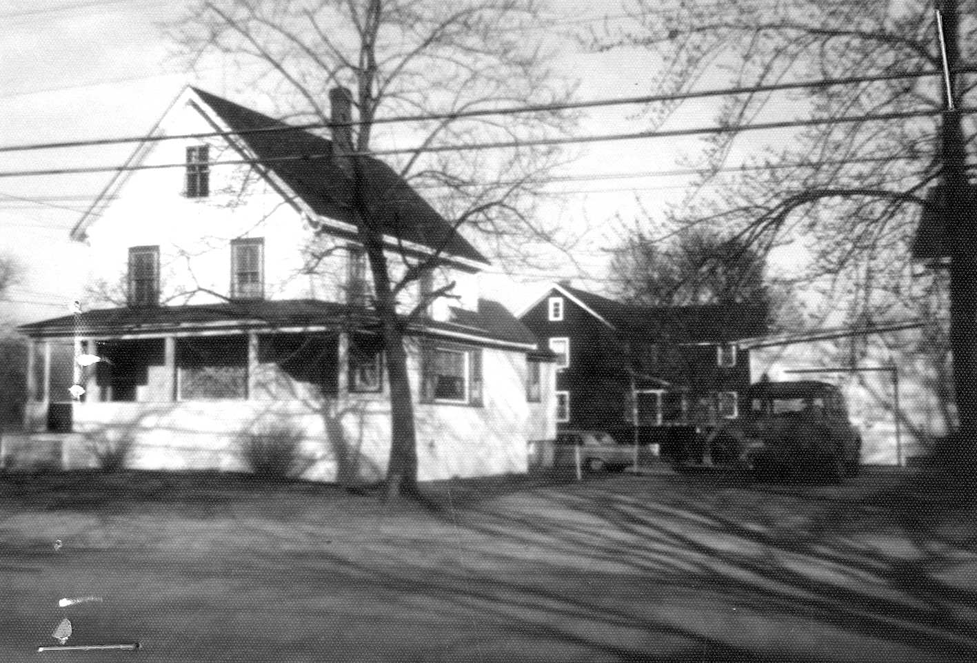
| Address | 37 Andover Rd |
| MACRIS ID | BIL.7 |
| Built | 1880 |
The Richardson Cottage at 37 Andover Road stands on land that was part of the thirty acres south of the road which Ichabod G. Kimball bought from Jonathan Gates in 1834, out of the former estate of Capt. Josiah Bowers. On July 9, 1877 Kimball, a yeoman and unmarried, sold John O. Richardson 147 square rods on Andover Street for $700, by a plan of Samuel Sage, beginning "at said street at other land of mine." Richardson, who ran a sawmill in East Billerica, was then building houses around the Centre village, partly as an outlet for his lumber and partly as investments.
He built a house on the north-east half of the lot first and sold it "with the buildings thereon" to Samuel G. Parker of Lowell in November 1880 for $3,500; that house became the Watts House at 39 Andover Road. The deed bounded the sold half on the west by "other land of the grantor," with no building named there, so the cottage on the south-west half was built after November 1880; it appears under J. O. Richardson's name on the 1889 map. Like the plain houses he built and kept as rentals on Concord Road, it seems to have been built to let rather than for his own home, which was on Boston Road.
Richardson kept the half lot for the rest of his life. He died with a will between 1896 and 1898, his widow Pamelia acting as executrix, and his land passed to his children. Deeds of the Watts House from 1902 to 1912 bound it on this side by "land of heirs of John O. Richardson." On April 15, 1922 his son John A. Richardson and daughter Fannie P. R. Colby sold the whole south-west half, 120 feet on the road, to Thomas Elder and his wife Alice M. Elder, "excepting so much thereof as was conveyed by said Richardson to Samuel G. Parker."
The Elders made the cottage their home. In 1926 they let the Lowell Electric Light Corporation set a pole "on private property off Andover Street." In June 1942 they sold the south-west 61 feet of frontage, a bare lot of 6,224 square feet, to Harry and Sarah Jane Turner, with a right of way along its north side and another to reach "a garage they purpose to build." Alice died first, and Thomas Elder left the cottage by will to his grandson Elder W. Turner; the rear of the old lot went to Elizabeth E. Jenney.
In September 1947 Elder W. Turner had the cottage lot surveyed by John Thomas Brown as Parcel C, 6,082 square feet with 59 feet on Andover Street, the plan showing the house with its porch, a shed and a garage reached by a driveway. On September 8 he deeded it to Katherine V. O'Rourke of Lowell, who the same day deeded it back to him and his wife F. Lillian Turner as tenants by the entirety. The house, then numbered 46 Andover Road and later 37, appears again as Parcel C, the Turners' house and garage beside a shared driveway, on a 1958 driveway plan drawn for the Eatons behind it.
The Turners sold the cottage in January 1962 to private owners. It was sold again in 1970, 1984, 1991, 1998 and 2003. The Billerica Historical Commission recorded it in 1973 and 1974 as a plain Victorian cottage of about 1880, and it has been in the Billerica Centre local historic district since 1990.
References
- MACRIS BIL.7
- Billerica assessor, parcel 51-66-0: 0.14 acre, built about 1880, Plan 71-48 Parcel C, sales 1984-2003.
Title References
| Date | Type | Grantor | Grantee | Summary | Recorded |
|---|---|---|---|---|---|
| 1824 | Administration | Estate of Capt. Josiah Bowers of Billerica, gentleman, intestate | Andrew Bowers of Salisbury, N.H., administrator; his brothers and sisters, heirs | Estate of Capt. Josiah Bowers, 1824 (earlier title of the Kimball land) | Probate #2301 |
Josiah Bowers died intestate on Nov. 17, 1824, leaving no widow. His heirs (James Bowers, Luther French, Amos Muzzy, Jacob Norton by his attorney Joseph Locke, and others) asked that "Andrew Bowers Esq. of Salisbury" be administrator, and he was appointed Nov. 23, 1824. The personal estate was auctioned Feb. 16-17, 1825; the account allowed Apr. 25, 1826 shows personal estate of $310.42 and "proceeds of sale of Real Estate sold by order of the Judge" of $1220, with the guardian's account of $488.32 among the debts.
Title from:
Title passed to:
Related:
|
|||||
| May 31, 1834 | Heirs Quitclaim | Heirs of Andrew Bowers late of Salisbury, N.H., Esquire: Jacob and Hannah Norton; James Bowers of Fulton, Ohio (by Norton, attorney); William and Anna Muzzy of Lexington; Joseph and Ann B. Richardson of Hingham; Abraham and Frances B. True of Salem; Edward | Jonathan Gates of Lowell, machinist | Bowers heirs to Jonathan Gates, 1834, incl. about 30 acres south of the road | 331/506 (South) |
Dated Apr. 2, 1834, recorded May 31, 1834 (Billerica town book 13, pages 552-555). For $2,500, a quitclaim of the lands "of which Andrew Bowers ... died seized": "the homestead of Capt. Josiah Bowers" of about eleven acres "with the buildings thereon" on the north side of the Salem road and Sheldon's lane, its south-west corner at the lane and Theophilus Manning, north by Manning and Ichabod Everett to the former Luther French farm, east by the French farm and the Nahum Baldwin lot; about 30 acres on the east side of the road opposite (John and Henry Baldwin, Fitch Tufts, the Nahum Baldwin pasture); a quarter of the Baldwin pasture; and six acres of wood on Fox Hill by the old Fox Hill road. Andrew Bowers died in New Hampshire, where his estate was settled.
Title from:
Title passed to:
Related:
|
|||||
| September 22, 1836 | Warranty | Jonathan Gates of Billerica, machinist | Ichabod G. Kimball of Billerica, yeoman | Gates to Ichabod G. Kimball, 1834: the 30 acres from which this lot was cut | 354/457 (South) |
Dated June 30, 1834, recorded Sept. 22, 1836 (Billerica town book 15, pages 287-289). For $2,500, "formerly the homestead of Capt. Josiah Bowers deceased with the buildings thereon lying on the northerly side of the Salem road or Sheldon's lane so called containing about eleven acres," with 30 acres on the east side of the road opposite, 1 1/2 acres on the north side adjoining the first lot (north-east by the Luther French farm), and six acres of wood on Fox Hill, "being the same premises" quitclaimed to Gates by Jacob Norton and others on Apr. 2, 1834.
Title from:
Title passed to:
|
|||||
| March 10, 1880 | Covenant to Stand Seized (conditional) | Ichabod G. Kimball of Billerica | George W. Searles of Billerica | Kimball covenants his farm to George W. Searles, 1875 (the remaining land around the lot) | 138/261 |
Dated June 2, 1875, acknowledged June 20, 1875, recorded Mar. 10, 1880, six days after Kimball's death. For $1 and his support, Kimball covenants to stand seized of "my homestead farm": eleven acres "with the buildings thereon in which I now live" on the north side of the Andover road, 28 acres on the east side opposite, 1 1/2 acres adjoining the eleven acres (north-east by the Luther French farm) and six acres of wood on Fox Hill, his title from Jonathan Gates June 30, 1834 ("Book 354 Page 457"), except parts sold to John Ames, Gilman Fletcher and Thomas K. Shedd; to the use of Kimball and his wife Joanna P. for their lives and then of Searles, void if Searles failed to support them. Searles was meanwhile to have the farm and "the Westerly part of the house."
Title from:
Title passed to:
|
|||||
| July 9, 1877 | Deed | Ichabod G. Kimball of Billerica, yeoman, unmarried | John O. Richardson of Billerica | Kimball sells John O. Richardson the 147 square rods, July 1877 (bare land) | 124/501 |
Signed and recorded July 9, 1877, acknowledged before Dudley Foster. For $700, a parcel on Andover Street "beginning at said street at other land of mine," running S 63 3/4 E 11 rods 15 links, N 87 1/2 E 14 rods 10 1/2 links to land of Daniel W. Baldwin, N 55 W by Baldwin 10 rods 8 1/2 links to the street, and S 40 1/2 W by the street 14 rods 14 links, "containing one hundred and forty seven square rods" by a plan of Samuel Sage, July 1877; Richardson to build the fence. Bare land cut from the 30 acres south of the road that Kimball had owned since 1834; no title recital.
Title from:
Title passed to:
|
|||||
| November 19, 1880 | Quitclaim | John O. Richardson of Billerica (Pamelia Richardson releasing dower and homestead) | Samuel G. Parker of Lowell | Richardson sells the house on the north-east half (Watts House), Nov 1880, keeping the south-west half where this cottage stands | 142/515 |
Signed Nov. 16, acknowledged Nov. 17, recorded Nov. 19, 1880. For $3,500, "a certain tract of land with the buildings thereon situated on Andover Street on the southerly side thereof": from the north-east corner at the street and Baldwin land, S 55 E by Baldwin 170 feet to land of I. Kimball, S 37 1/2 W by Kimball 118.17 feet, then about 172 1/2 feet north-west by other land of the grantor to the street, and 120 feet by the street; 75 3/5 square rods, "being the Northeasterly half of land to me conveyed by deed of I. G. Kimball dated July 9th 1877 ... Book 124 Page 501." The first record of the house, built on the north-east half between 1877 and 1880.
Title from:
Title passed to:
|
|||||
| June 18, 1898 | Assignment of Mortgage | Pamelia Richardson, Executrix of the will of John O. Richardson | Fannie P. R. Colby of Billerica, his daughter | Richardson had died with a will by 1898 (Pamelia executrix); his heirs held this lot until 1922 | 298/343 |
"I, Pamelia Richardson, Executrix of the will of John O. Richardson," for $1,000 paid by Fannie P. R. Colby of Billerica, assign to her the mortgage given to John O. Richardson by Barnet Schwartz of Tewksbury on August 27, 1896 (Book 277, Page 557). Dated June 1, acknowledged at Billerica June 10 before Frederic A. Morey, recorded June 18, 1898, after an assignment of another of his mortgages to Pamelia. The record shows that John O. Richardson had died with a will between 1896 and 1898, his widow Pamelia acting as executrix; she lived on in the front half of the house until 1917, and the homestead came to their daughter Fannie, whose will left it to her daughters Eva R. and Florence A. Colby (Book 925, Page 119).
Title passed to:
Related:
|
|||||
| April 17, 1922 | Warranty Deed | John A. Richardson and Fannie P. R. Colby, wife of Homer H. Colby, both of Billerica, heirs of John O. Richardson (Ella B. Richardson and Homer H. Colby releasing) | Thomas Elder and Alice M. Elder, husband and wife, of Billerica | Richardson heirs sell the south-west half of the 1877 lot, with this cottage, to Thomas and Alice M. Elder, 1922 | 659/316 |
Signed and acknowledged April 15, 1922 before J. Dana Richardson, recorded April 17, 1922 ($3.50 stamps). Land "on the southerly side of the Andover Road so called": from the north-west corner on the road at land formerly of Kimball now of one Messer, S 63 1/4 E 190 feet by the fence at Messer land to land formerly of Kimball now of one Livingston, N 87 1/2 E 118 3/4 feet by Livingston to land formerly of Samuel G. Parker now of one Watts, north-westerly 172 1/2 feet by the fence at Watts land to the road, and S 40 1/2 W by the road 120 feet. "Being the same premises conveyed to John O. Richardson by Ichabod G. Kimball July 9, 1877 ... Book 124, Page 501, excepting so much thereof as was conveyed by said Richardson to Samuel G. Parker by deed dated November 16, 1880 ... Book 142, Page 515." The heirs sell the whole south-west half, with the cottage that stood on it by 1889.
Title from:
Title passed to:
Related:
|
|||||
| August 31, 1926 | Easement | Thomas Elder and Alice M. Elder of Billerica | The Lowell Electric Light Corporation | Elders grant the electric company a pole on the property, 1926 | 740/443 |
Signed August 23, 1926, acknowledged by Thomas Elder before Arthur J. Bernier the same day, recorded August 31, 1926. For $1, the right "to erect and maintain one (1) pole on private property off Andover Street" and to support ten wires and apparatus on it, with permission to enter, as on the company's plan R-2794 (margin: see Plan Book 49, Plan 16D). Electric service to the Elder house.
Related:
|
|||||
| June 10, 1942 | Quitclaim | Thomas Elder and Alice M. Elder, husband and wife, of Billerica | Harry Turner and Sarah Jane Turner, husband and wife, as joint tenants, of Billerica | Elders sell the south-west 61 feet of frontage (later Parcel B) to Harry and Sarah Jane Turner, 1942, keeping the cottage | 978/199 |
Signed and acknowledged June 9, 1942 before Marion D. Gould, recorded June 10, 1942. Land on the southerly side of Andover Road: from an iron pipe near a stone bound at the north-west corner on the road at land now or formerly of one Messer, south-east 100 feet by the Messer fence, north-east 63.48 feet to an iron pipe "at the land of Elder," north-west 100 feet to the road, and 61 feet by the road; 6,224 square feet. Subject to and with the benefit of "the right of way now used and located in part along the northerly or northeasterly side of said premises," with an added ten-foot right of way over the grantors' other land "to reach a garage they purpose to build." "A part of the premises conveyed to the grantors by deed of John A. Richardson and Fannie P. R. Colby dated April 15, 1922 ... Book 659, Page 316." The south-west 61 feet of the front, a bare lot; the cottage stayed on the Elders' north-east 59 feet (later Parcel C).
Title from:
Title passed to:
|
|||||
| September 10, 1947 | Quitclaim | Elder W. Turner of Billerica, grandson and devisee of Thomas Elder (F. Lillian Turner releasing dower and homestead) | Katherine V. O'Rourke of Lowell | Elder W. Turner, heir under Thomas Elder's will, conveys the cottage lot (Parcel C) to a straw, 1947 | 1075/561 |
Signed and acknowledged at Lowell September 8, 1947, recorded September 10, 1947 8:30 A.M. The land "with the buildings thereon situated on the southeasterly side of Andover Street": from the north corner on the street at land of one Watts, south-east 104.85 feet by Watts to land of Elizabeth E. Jenney, south-west 55.20 feet by Jenney, north-west 108.50 feet by other land of Jenney and land of Harry Turner et ux to the street, and 59 feet by the street. "Being a part of the same premises conveyed to my grandfather, Thomas Elder and his wife, Alice M. Elder, by John A. Richardson, et als, by deed dated April 15, 1922 ... Book 659, Page 316. Said Alice M. Elder died in said Billerica and her estate was duly administered ... My title to said premises is derived under the will of said Thomas Elder, late of said Billerica ... case number 271969." Subject to "the right of way as now established." Shown as Parcel C on the plan of Elder W. and Lillian Turner, July 7, 1947, recorded herewith (Plan Book 71, Plan 48). A straw conveyance, reconveyed the same day.
Title from:
Title passed to:
|
|||||
| September 10, 1947 | Quitclaim | Katherine V. O'Rourke of Lowell (John J. O'Rourke releasing curtesy and homestead) | Elder W. Turner and F. Lillian Turner, husband and wife, of Billerica, as tenants by the entirety | Straw reconveys the cottage to Elder W. and F. Lillian Turner, 1947 | 1075/562 |
Signed and acknowledged at Lowell September 8, 1947, recorded September 10, 1947 8:30 A.M. The same land "with the buildings thereon" on the south-easterly side of Andover Street, same bounds (59 feet on the street, 104.85 feet by Watts, 55.20 and 108.50 feet by Jenney and Harry Turner), "being the same premises conveyed to me by Elder W. Turner by deed of even date," shown on Plan Book 71, Plan 48. The straw deed back, putting the house in husband and wife as tenants by the entirety.
Title from:
Title passed to:
|
|||||
| 1962 | Quitclaim | Elder W. Turner and F. Lillian Turner, husband and wife, of Billerica | Private buyers (husband and wife) of Billerica | Turners sell 37 Andover Road to private owners, 1962; later private sales summarized | 1543/103 |
Dated January 4, 1962 (recital in Book 1917, Page 19), with a Home Savings Bank mortgage of the same date (Book 1543, Page 104). The parcel "with the buildings thereon" "now numbered 37 Andover Road, formerly called Andover Street," Parcel C on Plan Book 71, Plan 48, same bounds as 1947, "formerly numbered 46 Andover Road," "being the same premises conveyed to said grantors by deed of Catherine V. O'Rourke dated September 8, 1947 ... Book 1075, Page 562." Later private sales of Parcel C, 6,082 square feet (also Parcel C on Plan Book 89, Plan 162A, 1958): 1970 (Book 1917, Page 19, $21,500 with the mortgage assumed), 1984 (Book 2921, Page 63, $80,000), 1991 (Book 5729, Page 14), 1998 (Book 9028, Page 107) and 2003 (Book 15979, Page 39, $275,000).
Title from:
|
|||||
Recorded is Book/Page at the Middlesex North Registry of Deeds unless noted; Probate # is a Middlesex probate case, Ctf a Land Court certificate of title.